
Charting the Chesapeake 1590 - 1990
- Introduction
- Maps for Mariners
- Charts for Marylanders
- Chartmaking I: Copperplates to Computers
- Chartmaking II: Surveying the Seen and Unseen
- The Language of Charts
- Cartographers of the Chesapeake

Maps for Mariners
A chart is a road map for mariners. It tells them where they are, where they can sail safely, and delineates areas to avoid by describing the surface under the water. Anyone venturing out on the Chesapeake needs to consult a chart to ensure a safe voyage.
Today's charts provide mariners with a wealth of data. Hundreds of bits of information are readily available telling them virtually everything they need to know to reach their destination safely. Based on sophisticated surveys, modern charts reflect how much is known about the world below the surface.
Chesapeake mariners have not always had the benefit of such knowledge. Earlier charts were far less informative, depending on the state of exploration or survey work at a given time. The charts presented here reflect four hundred years of knowledge about the bay. They illustrate how new information was made available to mariners over time.
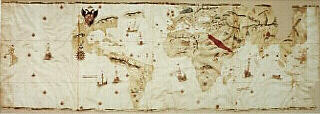
Map of the World
Juan Vespucci
Seville, Spain, 1526
This is the earliest map to show the existence of the Chesapeake Bay, called "Baya de Santa Maria." Juan Vespucci was the royal pilot of Spain's hydrographic office and nephew of Amerigo Vespucci, after whom North and South America are named. The information on this map came from a 1525 voyage by Pedro de Quexos.
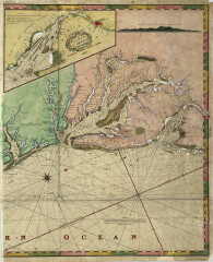
A New Chart of the Coast of America from Philadelphia to the Gulf of Florida [detail]
William Heather
London, 1815
Huntingfield Corporation Map Collection, MSA SC 1399-1-457
This is one of four sheets that make up the complete chart. The harbor insets are new additions to this privately-produced British chart, a feature that reduced the number of charts required on a voyage. Note also that the direction and speed of the current flow are indicated, information first included on a 1799 chart by Heather's partner, William Norie. This is a "blueback" chart, so names because it is backed with heavy blue paper or linen for durability.
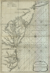
A New Chart of the Coast of North America from New York to Cape Hatteras
Capt. N. Holland [probably Samuel Holland]
London, 1794
Huntingfield Corporation Map Collection, MSA SC 1399-1-38
Samuel Holland completed this chart one year before the British Hydrographic Office was formed in 1795. It illustrates a wealth of information essential to navigation: soundings, shoals, and bottom conditions. The shoreline profiles assisted piloting, or navigating within sight of landmarks. Mariners used this chart well into the nineteenth century.
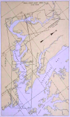
Small-craft Chart, Series 101: Potomac River
U.S. Coast & Geodetic Survey
Washington, DC, 1959
Huntingfield Corporation Map Collection, MSA SC 1399-1-761
This was the first small craft chart produced by the U.S. Coast & Geodetic Survey. It contains the kind of information skipper of recreational small craft need: the location of various services, photographs of port entrances, and tide and current information. This small book was designed for use on boats where larger charts were impractical.
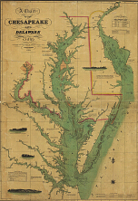
A chart of the Chesapeake and Delaware Bays
Fielding Lucas, Jr.
Baltimore, Maryland, 1832
Huntingfield Corporation Map Collection, MSA SC 1399-1-295
Fielding Lucas, Maryland's only active cartographer and map publisher of the time, added several new features to this chart of the bay. He used color to make the map more readable, included three scales for different latitudes, provided notes, tables of tidal information, and included data on navigational aids. Also, this was one of the first charts to show the Chesapeake-Delaware canal, constructed from 1824 to 1829.
|
This web site is presented for reference purposes under the doctrine of fair use. When this material is used, in whole or in part, proper citation and credit must be attributed to the Maryland State Archives. PLEASE NOTE: The site may contain material from other sources which may be under copyright. Rights assessment, and full originating source citation, is the responsibility of the user. |
© Copyright December 15, 2023 Maryland State Archives