
Charting the Chesapeake 1590 - 1990
- Introduction
- Maps for Mariners
- Charts for Marylanders
- Chartmaking I: Copperplates to Computers
- Chartmaking II: Surveying the Seen and Unseen
- The Language of Charts
- Cartographers of the Chesapeake

Cartographers of the Chesapeake
The cartographers of the Chesapeake were artists, explorers, businessmen, sea captains, and scientists. Whatever their backgrounds, however, their work combined the art of interpreting the bay's physical features and the science of plotting the exact location of those features.
John White
John White, an Englishman, was an artist and member of the
1585 expedition to establish the Roanoke colony, off the
coast of present-day North Carolina. He and Thomas
Harriot, philosopher, naturalist, and mathematician, were
employed to gather information about the New World.
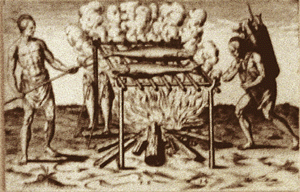
White's drawings of Eastern Woodland Algonquain Indian
life were used with Harriot's notes in
A Brief and True Report of the Newfound Land of
Virginia. White's granddaughter, Virginia Dare, was the first
child born of English parents in the New World.
What did John White look like? We do not have a clue since
no sketch of the artist himself has survived. Yet because
of John White's drawings that were published in addition
to his map, we have a glimpse of Indian life in the
Chesapeake region four hundred years ago.
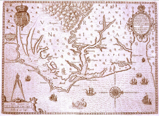
America Pars, Nunc Virginia Dicta... John White Frankfurt, Germany, 1590 Huntingfield Corp. Map Collection, MSA SC 1399-1-207 John White's map was the first to identify the bay by its present name. (You can find the words "Chesepiooc Sinus" in the middle right side of the map.) White's map shows only the mouth of the bay, since the remainder had not been explored by his expedition. The decorative touches in White's map reflect his training as an artist and contrast with the scientific approach employed in modern chartmaking.
Augustine Herrman
Augustine Herrman was born in Prague, Bohemia
(Czechoslovakia) in 1605. His family eventually settled in
Amsterdam, a leading center of commerce and trade at that
time. By 1644, Herrman was an agent for a large shipping
company in New Amsterdam (New York). He then established
his own trading company and also engaged in farming,
fur-trading, and land speculation. By the mid-1650s he was
one of the leading merchants and citizens of New
Amsterdam.
In 1659 Herrman applied to become a resident of the
territory of Maryland. Lord Baltimore approved the request
and in 1662 Herrman received the first of several
extensive grants of land, which totaled between twenty and
twenty-five thousand acres. Herrman established his
residence, called Bohemia Manor, on a 6,000 acre tract
located on both sides of the Elk River in present day
Cecil County. First surveyed in August 1661, it was
granted to Herrman by patent of June 19, 1662, in exchange
for his promise to make a map of the territory.
Herrman conducted surveys for his map from 1659 to 1670
and spent the next several years plotting, drafting, and
ornamenting the map, He sent his finished manuscript to
London, where William Faithorne engraved it in 1673.
The Herrman map was copied and adapted by mapmakers for
more than a century after its publication. It was
especially important in helping to solve the boundary
disputes between Maryland, Virginia, and Pennsylvania.
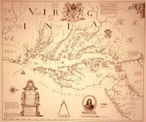
Virginia and Maryland as it is Planted and Inhabited this Present Year 1670, Surveyed and Exactly Drawne by the Only Labour & Endeavour of Augustim Herrman Bohemiensis Augustine Herrman London, 1673 [1970] Reproduction of facsimile from the Huntingfield Corporation Map Collection, MSA SC 1399-1-679 Herrman's map was the prototype for charts of the Chesapeake for over sixty years. Based on his own surveying and sources, it had more information for the navigator than anything else publicly available. Its navigational use, however, was hindered by its four-sheet format.
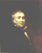
Ferdinand Rudolph Hassler
Ferdinand Hassler was a Swiss mathematician who had
extensive surveying experience. When the U.S. Congress
authorized an official Survey of the Coast in 1807,
Hassler, who was between teaching appointments in
Philadelphia, became interested in the enterprise. After
Hassler was appointed to the post in 1811 he immediately
set off to Europe where he had special instruments made to
do the survey work.
Hassler was the first superintendent of the U.S. Coast
Survey and insisted on an unprecedented level of
scientific accuracy. His surveyors carried out their
triangulation -- fixing the relative positions of
different locations of the earth's surface by use of a
network of triangles -- according to strict geodetic
principles. This careful approach delayed the production
of charts and thus brought criticism from individuals
within the government. Yet Hassler's legacy was in the
sound scientific base of the bureau's work. While it was
expensive and time consuming, U.S. charts became the
standard for the world.
Edmund Blunt
Edmund March Blunt was born in Portsmouth, New Hampshire,
in 1770. He became America's most notable early
hydrographic with the publication in 1796 of the
American Coast Pilot, the first book of
sailing directions compiled and printed in the United
States. Blunt continued to publish updated volumes of the
American Coast Pilot, describing all coasts
of the United States.
Blunt's sons, Edmund and George, devoted their lives to
charting and the sea as well. Edmund was hired by the U.S.
Coast Survey for whom he worked on triangulation of the
bay, among other duties. George Blunt became a publisher
of charts and nautical books in New York. He revised the
American Coast Pilot several times and was a
major force behind causing the federal government to
organize the Lighthouse Board. After the death of the
elder Blunt in 1862 and Edmund Blunt, Jr., in 1867, George
sold the copyright for
American Coast Pilot to the U.S. Coast
Survey.
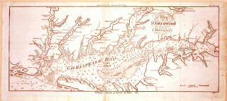
The Bay of Chesapeake from its Entrance to Baltimore
Edmund M. Blunt
Newburyport, Massachusetts
Huntingfield Corp. Map Collection, MSA SC 1399-1-191
This chart was among the first prepared and published in
the United States. It showed both true and magnetic north,
a new feature for charts of the bay. (You can see true and
magnetic north marked beneath the work "Bay" in the center
of the chart.) It was also one of the earliest charts to
show navigational aids. (See Cape Henry Lighthouse in the
lower left of the chart.)
Cartographers for the National Ocean Service
Cartographers for the National Ocean Service (NOS) of the
National Oceanic and Atmospheric Administration (NOAA)
compile and construct charts for about 2.5 million square
nautical miles of the nation's coastal waters, the Great
Lakes, and connecting waterways. They work with data from
surveys and other sources in constructing and revising
charts.
The work of modern-day cartographers is varied. Some
participate in surveys or assist with hydrographic
observations aboard ships of the National Ocean Survey
fleet. Others evaluate survey data to ensure it accuracy.
Cartographers today use aerials photographs to plan
extensive field surveys and to map shore detail. They also
operate special survey instruments and process data
through computers to determine exact positions of data. In
addition, they compute direction information obtained from
orbiting satellites. Experience cartographers engage in
research and development to devise improved cartographic
methods and portrayal techniques.
Cartographers today typically have advanced degrees and
experience in fields such as mathematics, astronomy,
cartography, engineering science or drafting, geodesy,
geography, geology, geophysics, meteorology, navigation,
oceanography, physics, and surveying.
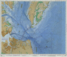
United States-East Coast, Virginia: Chesapeake Bay
Entrance
National Oceanic and Atmospheric Administration (NOAA)
Washington, DC 1986
Huntingfield Corp. Map Collection, MSA SC 1399-1-747
This experimental chart was produced by the National Ocean
Service (NOS) of NOAA to examine possible improvements in
traditional charts. Among the changes proposed were to
highlight fish havens and disposal areas and to subdue
road designations and compass roses. It was submitted to
the International Hydrographic Organization conference in
1987. The National Ocean Service surveyed user
organizations for their reactions to the changes, some of
which were adopted while others were rejected. This
experimental chart was part of a continuing effort to
achieve worldwide standardization of nautical charts and
to improve chart usefulness.
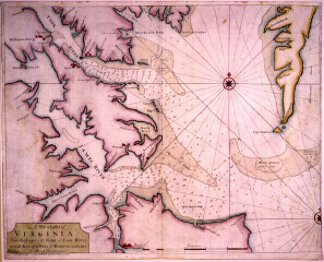
A Draught of Virginia from the Capes of York in York River
and to Kuiquotan or Hampton in James River Mark
Tiddeman
London, 1729
Huntingfield Corp. Map Collection, MSA SC 1399-1-29
Tiddeman was master of the British vessel
Tartar from 1724 to 1728. While patrolling
the mouth of the bay, he made extensive soundings which
were published in The English Pilot. The
soundings were the most complete available for the area at
that time.
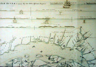
Plan of the Peninsula of Chesopeak Bay
John Hills
Unpublished manuscript, 1781
Copy of detail courtesy of the William L. Clements
Library, University of Michigan
John Hill's manuscript was the first surviving chart to
feature profile views of the shoreline. Such views were
helpful for coast piloting -- navigating within sight of
land -- and were widely used for seventy-five years. Hills
did his manuscript in pen and tinted it with water colors.
It was probably used by the British during the
Revolutionary War.
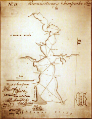
N. 11 Reconnoitering the Chesapeake Bay 1818
U.S. Topographical Bureau
Unpublished manuscript chart, 1818
Huntingfield Corp. Map Collection, MSA SC 1399-1-334
The War of 1812 called attention to the inadequacy of
charts furnished to the U.S. Navy. As a result, the
government organized surveys of the Chesapeake Bay and its
harbors. The survey included extensive soundings like
those shown here, crisscrossing the St. Mary's River.
Today teams of specialist rely on sophisticated instruments for measuring and analyzing the physical characteristics of bodies of water. Their forerunners were not so specialized, nor did they have the benefit of such highly accurate instruments. Early charts were based on data collected by explorers, navigators, sea captains, or military men. Their instruments often served two purposes: one for obtaining data to record on the chart and the other for navigating in conjunction with a chart.

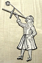
Backstaff
Early mariners used the backstaff to determine their
latitude by measuring the altitude of the sun at noon.
Introduced by John Davis of London in 1594, the backstaff
was so named because, unlike the cross-staff which it
replaced, the user had the sun behind him when taking an
observation. The backstaff was also known as Davis'
quadrant.
Cross-staff
The cross-staff, forerunner of the backstaff, was used by
mariners to determine latitude at sea by measuring the
altitude of the sun at noon. Its chief drawback was that
it forced the user to look directly at the sun to take a
reading. From John Seller's
Practical Navigation, first printed in 1669.
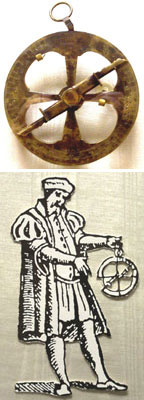
Mariner's Astrolabe
The mariner's astrolabe was the forerunner of the
backstaff, quadrant, octant, and modern sextant developed
to measure the altitude of the sun or stars. A mariner
could determine his latitude by means of these
instruments.
The astrolabe consists of a graduated ring of brass fitted
with a sighting rule, pivoted at the center of the ring.
The astrolabe is suspended by the thumb or by means of a
thread from a shackle at the top of the ring so that it
hangs vertically. The sighting rule is then turned about
its axis so that the sun or star can be sighted along it
and the altitude read off on the ring.
The astrolabe was used from the late fifteenth century
until the end of the seventeenth century. It was of little
use for observations from the heaving deck of a ship at
sea but was of considerable use in charting the
approximate latitudes of new discoveries where
observations were made on shore.
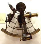
Octant
The octant uses an eyepiece and mirror to measure the
altitude of heavenly bodies. It has an arc of one-eighth
of a circle, but its design permits the measurement of
altitude up to 90 degrees. Octants remained in use by
navigators until 1800 when they were replaced by sextants.
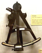
Sextant
Using a small telescope and an arrangement of mirrors, the
sextant allows the sailor to measure the angle of the sun
or a star above the horizon. Invented in the 18th century
by John Hadley, the sextant is used to determine a ship's
latitude.
|
This web site is presented for reference purposes under the doctrine of fair use. When this material is used, in whole or in part, proper citation and credit must be attributed to the Maryland State Archives. PLEASE NOTE: The site may contain material from other sources which may be under copyright. Rights assessment, and full originating source citation, is the responsibility of the user. |
© Copyright March 24, 2026 Maryland State Archives