
View Maryland Counties
- Allegany
- Anne Arundel
- Baltimore City
- Baltimore County
- Calvert
- Caroline
- Carroll
- Cecil
- Charles
- Dorchester
- Frederick
- Garrett
- Harford
- Howard
- Kent
- Montgomery
- Prince George's
- Queen Anne's
- St. Mary's
- Somerset
- Talbot
- Washington
- Wicomico
- Worcester
Harford County
 Harford County, located in the northeast corner of the Western
Shore, is bordered to the north by the Mason-Dixon line and
Pennsylvania, the east by the Susquehanna River, the south by
the Chesapeake Bay, and the west by Baltimore County. It was
formed from Baltimore County by Chapter 6, Acts of 1773. The
county is named for Henry Harford, last proprietor of Maryland
and a son of Frederick Calvert, sixth Lord Baltimore.
Harford County, located in the northeast corner of the Western
Shore, is bordered to the north by the Mason-Dixon line and
Pennsylvania, the east by the Susquehanna River, the south by
the Chesapeake Bay, and the west by Baltimore County. It was
formed from Baltimore County by Chapter 6, Acts of 1773. The
county is named for Henry Harford, last proprietor of Maryland
and a son of Frederick Calvert, sixth Lord Baltimore.
Bel Air, the county seat, serves as the trading and banking center of the surrounding countryside. When Harford County was created in 1773, the county seat was established at Old Harfordtown on the Bush River. In 1782 the county seat was moved to Aquila Scott's Old Field, which was eventually renamed Bel Air, although the town was not incorporated until 1874.
Many interesting historic sites are located in Harford County. Jerusalem Mill, on the Little Gunpowder River, was built partly by David Lee in 1772. The mill is unusual in that the first story is of stone, and the second frame, surmounted by two half stories under a steep gabled roof. Although Lee was a Quaker, he supposedly manufactured guns in the stone building behind the mill during the Revolution. Nearby is the Jericho Covered Bridge. Of bowstring construction, the bridge is said to have been built about 1800, making it one of the oldest such bridges now in Maryland. In old Joppa Town, the Rumsey House can be seen, an interesting two and a half story brick structure with a gambrel roof. The house was acquired about 1771 by Colonel Benjamin Rumsey, a member of the Continental Congress.
MSA SC 1477-5647
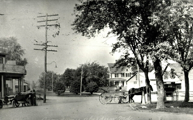
Although Aberdeen has gained its notoriety as the location of the federal government's testing grounds for ordinance, shells, bombs, mines, and other military material, the town existed well before the Proving grounds came into being. This view of Broadway, c. 1910, shows Aberdeen in sleepier days.
MSA SC 1477-6152
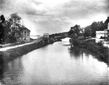
The Susquehanna and Tidewater Canal, seen here at Lapidum, was once part of a viable shipping route between Baltimore and Philadelphia. Begun in 1839, by 1900 the canal was a relic.
MSA SC 1477-6150
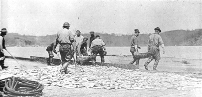
Fishing has long been a profitable enterprise for those living along the shores of the Susquehanna River. This crew was working just above Havre de Grace in 1899.
MSA SC 1477-5336
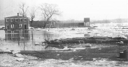
The lock keeper's house at Havre de Grace fell into severe disrepair after the closing of the Susquehanna and Tidewater Canal. An ice gorge on the river was in progress at the time this picture was made. In recent years the house has been restored and transformed into a museum.
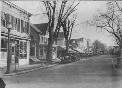
MSA SC 1477-5908
Bel Air was not incorporated until 1874, although it had been the county seat since 1782. The general appearance of the town has remained remarkably unchanged since 1933 when this view was made.