The Geography of Baltimore City: Sources
Resources for locating maps and understanding the mapping of Baltimore City.
Our Map Collections:
The Baltimore City Archives has an extensive collection of maps, both in facsimile and original. Most maps in our collection are located in BRG12 and BMS10.
Below are the available indexes to our collection. The contents of these indexes overlap. These indexes are searchable by street name and to a lesser extent by neighborhood name. Please ask one of our archivists for assistance in interpreting the indexes.
Index of Streets and Alleys found in . . . the Baltimore City Archives: transcription of original typescript index
Chronological map list with descriptions (Maps through 1851)
Legacy microfilm index correlates maps to microfilm reels
Note that street names and numbers have changed over the years. Please consult with the following sources to trace older addresses:
Duvall’s Practical Points for Conveyancers (1894)
1908 City Council proceedings: Listing of street name changes
1887 Street renumbering guide from the City Directory
How to Begin research:
To understand Baltimore City's geographic and demographic growth, the following resources to the mapping of the city are recommended.
Sherry Olson's Baltimore: The Building of an American City
Edward Papenfuse and Joseph M. Coale's Atlas of Historical Maps of Maryland.
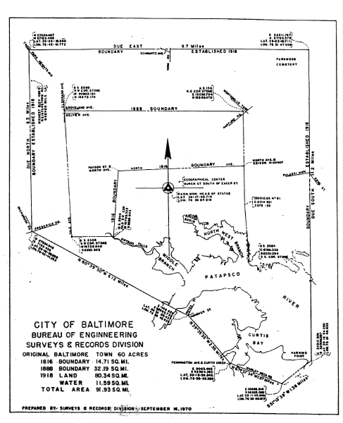
Map of city annexations over time
I. Useful base maps and images include:
Historical Growth of Baltimore Historical Growth Map of City of Baltimore (1.127 Mb)This map was created in 1977 by the Department of Public Works and documents the growth in boundaries of the City. While the copy here is not the best, it is possible to zoom into block numbers and streets as they were in 1977. These maps used to be distributed freely by the Department of Public Works. Baltimore City and County Aerial Photos: 1926
Aerial Photographic Map Atlas, created in 1926-1927 for the Department of Public Works, Water and Wastewater, located in our collection at BRG47-39.
Base map for Baltimore: 1935
Stieff, 1935 map of Baltimore City (47.588 Mb)
Attached is a large pdf of a map showing the streets and wards of Baltimore in 1935. The map accompanied Frederick Stieff’s The Government of a Great American City (Baltimore: H. G. Roebuck & Son, 1935).
2008 Council Districts (731.648 Kb)
II. Sanborn Insurance maps, Bromley and Thompson Atlases, Baltimore City Block Maps
The Baltimore City Archives has several physical reference sets of the Sanborn maps of Baltimore City available to browse. These copies were updated by the Sanborn map company through the 1950s and contain pasted down changes in buildings through the last date of update for each volume.
The Library of Congress has posted an excellent online collection of Baltimore City Sanborn atlases. These are original, uncorrected versions, which can be useful to compare to the corrected ones.
Additional Sanborn reference documents:
- Baltimore street and street number index to the Sanborn maps as of 1945
- Guide to using the Sanborn Maps (greyscale; does not show color codes)
The Pratt Library also has a Sanborn Map database, located at:
Note that to access the maps, you will need to enter your Pratt Library card barcode. Also note that these are black and white images rather than color; color is very important in interpreting the Sanborn maps, so these images have limited utility.
Similarly, the Maryland State Archives has a collection of digitized microfilm of the Sanborns through 1963 from Library of Congress microfilm; see MSA SC2907.
Additional links to digitized Baltimore City atlases hosted by Maryland State Archives (grayscale unless otherwise indicated):
- 1876, Baltimore City, Hopkins Atlas (JHU copy), images 785/868,
- 1885, Baltimore City, Bromley Atlas, Volume 1, North West Section, images 1/85
- 1886, Baltimore City, Bromley Atlas, Volume 2, North East Section, images 86/158
- 1889, Baltimore City, Thompson Atlas, 21/22 Wards, images 479/565
- 1889, Baltimore City, Thompson Atlas, 21/22 Wards (color plates), images 889/964
- 1896, Baltimore City, Bromley Atlas, images 159/262
- 1898, Baltimore County, Bromley Atlas, images 263/371
- 1906, Baltimore City, Bromley Atlas, images 372/478
- WBA Railroad Route, image 477
- 1914, Baltimore City, Topographical Survey, images 689/729
- 1915, Baltimore County, Bromley Atlas (Isekoff copy), images 730/784
- 1915, Baltimore County, Bromley Atlas (Whitney copy), images 869/888
Block Books
Baltimore began recording land transactions by city blocks in 1851. Baltimore Block Books are available through the Maryland Land Records website.
The best maps of Baltimore City blocks with their block numbers are to be found in the Bromley Atlases for the City (see above), a 1991 atlas, Baltimore City Block maps, part 1, as of April 2005 (thumbnails), and Baltimore City Block maps, part 2, as of April 2005 (thumbnails).
III. Johns Hopkins University Maps and Atlases
One of the best collection of digitized maps and aerial photographs of Maryland, with emphasis on the Baltimore region, is via Johns Hopkins University Library: Maps and Atlases Digital Repository.
IV. Ground Rents
Note that attempting to trace the ownership and occupancy of property in Baltimore City is complicated by ground rents. For a legal explanation of ground rents, see Frank A. Kaufman’s article in the Maryland Law Review, Volume 5, issue 1, 1940, "The Maryland Ground Rent – Mysterious but Beneficial."
For the history of ground rents in Baltimore City, one of the best sources is
"Parceling Out Land in Baltimore, 1632-1796" by Garrett Power (reprinted from the Maryland Historical Magazine in 1993).
See also Professor Power’s comparative study of Baltimore and Birmingham, England.
Another useful study is
Ground Rents in Maryland with an Introduction concerning the Tenure of land under the Proprietary,
by Lewis Mayer, 1883.
For an example of the difficulty in tracing ground rents, see Documenting Ground Rents in Baltimore City.
V. Secondary sources re: the mapping of Baltimore City:
In addition to the Maryland State Archives'�Atlas of Historical Maps of Maryland (2003), which is available only in print, see:
- Arnold, Joseph L. “Suburban Growth and Municipal Annexation in Baltimore, 1745-1918” Maryland Historical Magazine (June 1978): 109-128.
- Cox, Richard C. “Understanding the Monumental City: A Bibliographical Essay on Baltimore History” Maryland Historical Magazine (March 1982): 70-111.
- Cox, Richard C. “Trouble on the Chain Gang: City Surveying, Maps, and the Absence of Urban Planning in Baltimore, 1730-1823; With a Checklist of Maps of the Period.” Maryland Historical Magazine (Spring 1986): 8-49.
- Lefurgy, William G., “Baltimore’s Wards, 1797-1978: A Guide” Maryland Historical Magazine (June 1980): 145-153.
- Smith, Dawn Beitler. Index to the Map of the City and County of Balitmore, 1850, by J. C. Sidney and P. J. Browne, n. d. (searchable pdf derived from uncopyrighted typescript printed by Family Line Publications, Westminster, Maryland).