 |
||||
|
STATE ROADS COMMISSION (Minutes) Liber 1, 1908-1913 MSA SE3-1 Image No: 14677-0067 Enlarge and print image (63K) |
 |
||||
|
STATE ROADS COMMISSION (Minutes) Liber 1, 1908-1913 MSA SE3-1 Image No: 14677-0067 Enlarge and print image (63K) |
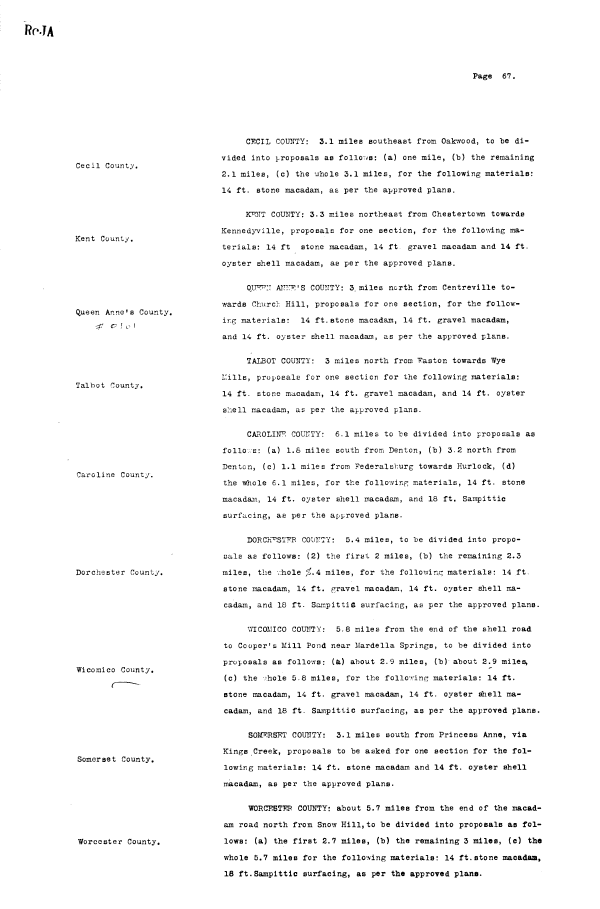
| RoJA Page 67. Cecil County, Kent County. Queen Anne's County. ^ v ! o I Talbot County. Caroline County. Dorchester County. Wicoraico County. Somerset County. Worcester County. CECIL COUNTY: 3.1 miles southeast from Oakwood, to be divided into proposals as follows: (a) one mile, (b) the remaining 2.1 miles, (c) the v;hole 3.1 miles, for the following materials: 14 ft. stone macadam, as per the approved plans. K^NT COUNTY: 3.3 miles northeast from Chestertown towards Kennedyville, proposals for one section, for the follovdLng materials: 14 ft stone macadam, 14 ft gravel macadam and 14 ft. oyster shell macadam, as per the approved plans. AlIT-r^'S COUNTY: 3. miles north from Centreville towards Church Hill, proposals for one section, for the following materials: 14 ft. stone macadam, 14 ft. gravel macadam, and 14 ft. oyster shell macadam, as per the approved plans. TALBOT COUNTY: 3 miles north from "Fasten towards Wye L'ills, proposals for one section for the following materials: 14 ft. stone macadam, 14 ft. gravel macadam, and 14 ft. oyster shell macadam, as per the approved plans. CAROLINA COUNTY: 6.1 miles to be divided into proposals as follo.vs: (a) 1.6 miles south from Denton, (b) 3-2 north from Denton, (c) 1.1 miles from Federalsburg towards Hurlock, (d) the whole 6.1 miles, for the follov/lng materials, 14 ft. stone macadam, 14 ft. oyster shell macadam, and 18 ft. Sampittic surfacing, as per the approved plans. DORCK^ST'FR COUNTY: 5.4 miles, to be divided into proposals as follows: (2) the first 2 miles, (b) the remaining 2.3 miles, the -./hole ,€.4 miles, for the following materials: 14 ft. stone macadam, 14 ft. gravel macadam, 14 ft. oyster shell macadam, and 18 ft. SainpittiC surfacing, as per the approved plans. V/ICOMICO COUNTY: 5.8 miles from the end of the shell road to Cooper's Mill Pond near Mardella Springs, to "be divided into proposals as follows: (a) about 2.9 miles, (b) about 2.9 miles, (c) the hole 5.8 miles, for the folio-ring materials: 14 ft. stone macadam, 14 ft. gravel macadam, 14 ft. oyster shell macadam, and 18 ft. Sampittic surfacing, as per the approved plans. SOMERSET COUNTY: 3.1 miles south from Princess Anne, via Kings Creek, proposals to be asked for one section for the fol-lowing materials: 14 ft. stone macadam and 14 ft. oyster shell macadam, as per the approved plans. WORCEBTTIR COUNTY: about 5.7 miles from the end of the macadam road north from Snow Hill, to be divided into proposals as follows: (a) the first 2.7 miles, (b) the remaining 3 miles, (c) the whole 5.7 miles for the following materials: 14 ft. stone macadam, 18 ft. Sampittic surfacing, as per the approved plans. |