|
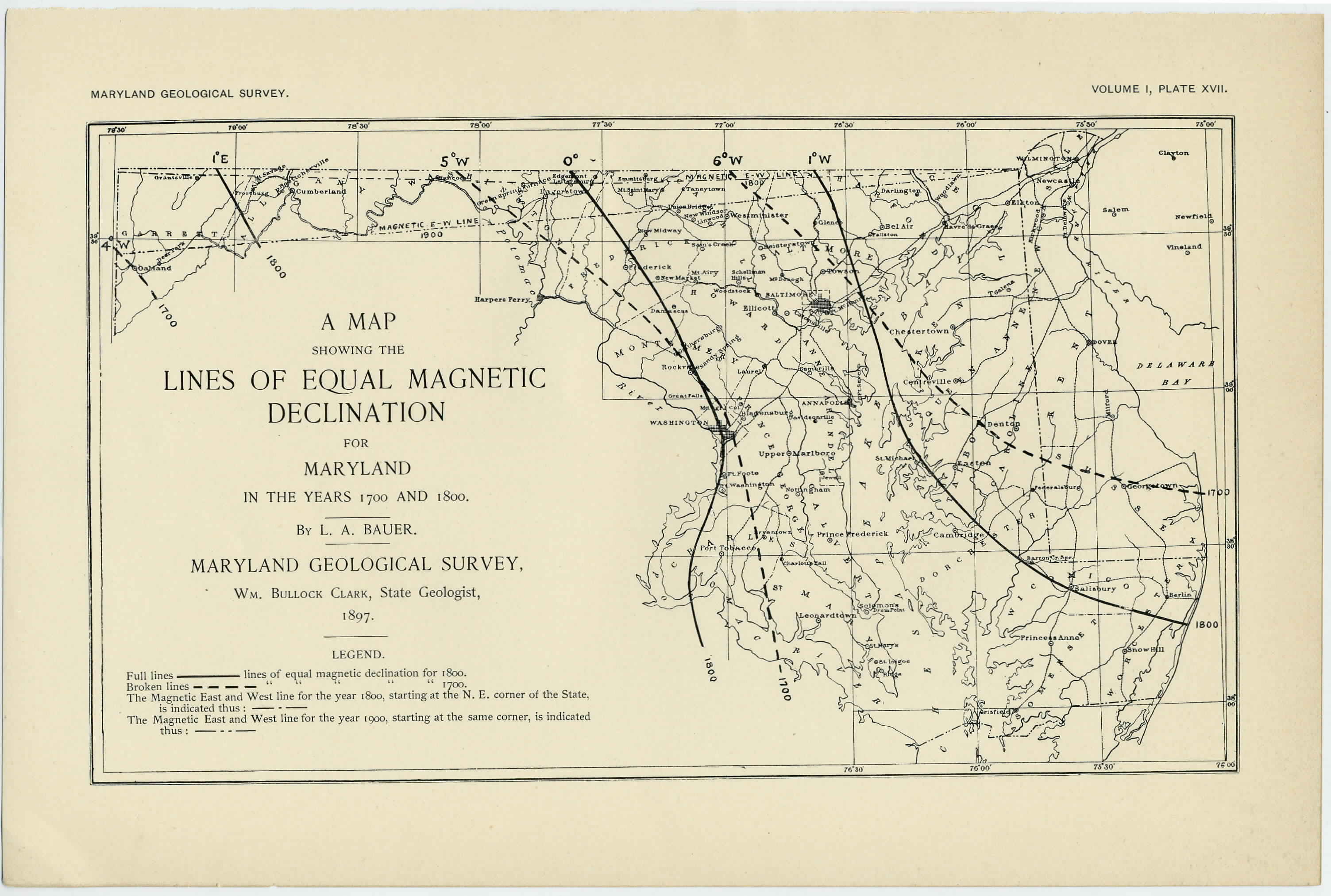
[Preceding page is an image: Map showing the Lines of Equal Magnetic Declination for Maryland in the years 1700 and 1800]
MARYLAND GEOLOGICAL SURVEY 495
We thus see that the line of no declination entered the state in
about 1769 and thereupon marched eastward until it reached an
extreme easterly position a few miles east of Washington in about
1805. It then began to recede, now marching westward until in
about 1850, when it left the state. The average annual motion in
longitude for the forward and the backward march was about the
same—0°.7, or about 37 miles. The next map (Fig. 7) exhibits the
motion of the agonic line over the eastern part of our country for
various epochs, as drawn by Mr. Schott. It will be noticed that our
deductions are in harmony with the facts set forth by this map.
It would appear, then, as though the needle did not point east of
north between 1700 and the present date in the greater part of Mary-
land. It should be mentioned, however, that there may have been
regions east of the extreme easterly position assumed by the agonic
line where the needle in the early part of the eighteenth century was
either " true to the pole " or bore by a small amount east. This
occurred in the magnetically disturbed areas of Maryland and was
due to the fact that in those regions the declination has a smaller value
than it would have if the causes of the disturbances did not exist.
Thus, for example, we find that at Elkton in about 1800 the direction
of the needle practically coincided with the true meridian, whereas
if the declination had been normal it would have been about l£° west.
It is this fact undoubtedly which makes the matter of re-locating old
surveys of such especial difficulty in the northeast counties. There
are disturbed and undisturbed areas in these counties. Over the
former the needle may have pointed east at beginning of present cen-
tury; over the latter, which may be within a very short distance of
the former, the needle pointed west. Granted that over this region
compass surveying should be prohibited in the future by the state,
the difficulty will always remain in the proper re-location of the old
surveys referred to compass bearings.
THE EFFECT OF THE SECULAR VARIATION OF THE MAGNETIC MERIDIANS.
If in the year 1800 the northern boundary of Maryland—the
famous Mason and Dixon line—had been laid out with the compass
|