Annapolis, MD 21401
MD toll free (800) 235-4045
or (410) 260-6400
fax: (410) 974-2525
email:
msa.helpdesk@maryland.gov
![]()
|
|
Maryland State Archives |
350 Rowe Boulevard Annapolis, MD 21401 MD toll free (800) 235-4045
or (410) 260-6400
fax: (410) 974-2525
email:
msa.helpdesk@maryland.gov
|
|
|
||
|
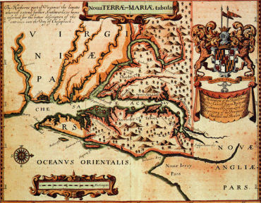
Ogilby Map
Citation: Maryland State Archives Special Collections (William T. Snyder Map Collection) John Ogilby, 1671 Noua Terrae-Mariae Tabula MSA SC 2111-1-2
John Ogilby's map of Maryland was published as part of his America: Being the Latest, and Most Accurate Description of the New World (London, 1671). The orientation of the map showing North to the right reflects the purpose of the chart design. It is a Portolan, or port-finding chart, used by ship captains approaching the entrance of the Chesapeake Bay from the sea. The cartographer probably copied this map from Captain John Smith's influential map of 1608.
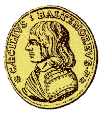
Ogilby's map is noteworthy for being the first to describe the names of the counties of Maryland. In fact, Ogilby must have been privy to information from Cecil Calvert, Lord Baltimore, the Proprietor of Maryland, because Cecil County (Caecill on the map) officially was not created until 1674.
The map also features the Calvert coat of arms. The quartered Calvert and Crossland arms continue to be used today as the basis of the Maryland state flag, the only state flag in the United States based on a heraldic design.
View a more detailed version of the map here. (469 KB)
The Maryland State Archives houses one of the most extensive collections of maps relating to Maryland and the Chesapeake Bay region. Color reproductions of the 1671 Ogilby map are available as an 18 x 21 poster (MSA Publication #289) and a boxed set of 10 notecards and envelopes (MSA Publication #420). The price is $10.00 for either the poster or the notecards.
|
|
Tell Us What You Think About the Maryland State Archives Website!
|
© Copyright March 03, 2005 Maryland State Archives