MSA SC 4386, sections 5, 6, 7, 12, 13, 14.
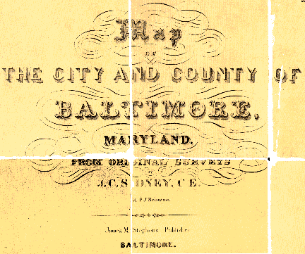
Map of the City and County of Baltimore, Maryland, from Original Surveys
J.C.Sidney and P.J. Brown, 1850, published James M. Stephens, Baltimore. Copyright, Robert P. Smith, Philadelphia MSA SC 4386
Joseph M. Coale III, a Baltimore collector of maps and co-author of The Hammond-Harwood House Atlas of Historical Maps of Maryland, 1608-1908, recently lent the Archives a map of Baltimore County, published in 1850, for conservation treatment. This allowed the Archives' conservator, Hanna Szczepanowska, the opportunity to work with a unique object and one that the Archives did not have in its collection.
The map depicts Baltimore County with an inset of Baltimore City. There is a decorative floral border with illustrations of sites and buildings in corner and center medallions. The engraving is enhanced with watercolor.
Historical Context
The Map of the City and County of Baltimore is representative of a number of maps published from mid to late nineteenth century. The publisher's goal was to provide information about roads, election districts, towns, homes, farms, and businesses for local residents. In addition to soliciting subscriptions, marketing efforts also extended to those who were willing, for an additional fee, to have the location of their home, business, or property placed on the map.
James M. Stephens, the publisher of the map, retained the services of Robert P. Smith to undertake the cartography and printing. Robert Smith was involved in the preparation of many county maps from 1846 to 1864. Although he appears as publisher on only few maps, he was instrumental in the publication of 100 or more land ownership maps with others. In many instances, he provided survey and mapping expertise to local businessmen, such as Stephens, who were responsible for subscription sales and marketing.
James C. Sidney, the surveyor of the map, also prepared maps of Essex County, New Jersey, and Dutchess and Richmond counties, New York, and Philadelphia.
On March 30, 1850, the Baltimore County Advocate published a notice soliciting subscribers. Work was completed during the summer and an advertisement in the Advocate on September 14, 1850 advises that the map is available. This same issue offers a brief review, making note of some errors, and observing, "we can heartily recommend the map to our readers, as forming a not only an ornamental but useful appendage to the walls of hall or cottage, where on some rainy day, every one may travel around the county and see how his fellow citizens are fixed, without stirring from under his own shingles".
 Baltimore County Advocate, September 14, 1850, MSA M 3331
Conservation Analysis
The map that Mr. Coale brought to the Archives was folded and assembled in 35 sections which were mounted on canvas. The map was printed on two sheets, top and bottom, which were glued together for flat display. An earlier owner decided it would be more useful as a pocket map and had it cut in sections. In addition to gluing the sections onto canvas, at least one cover board, and likely a second, were attached to the canvas. The map was coated with shellac which yellowed unevenly. Brown discoloration from the glue used for mounting was visible on verso of the map in a pattern of brush strokes.
The map was soiled unevenly with small, light brown stains scattered throughout. A stain at the top left portion, probably caused by liquid, weakened the paper causing it to tear in the center of the stain.
The top and bottom margins were cut off at some point in the past, removing part of the medallions. The top right section of the map was torn, abraded, and creased. This was the most severely damaged area of the map.
The metal plate engraving was enhanced with hand-applied watercolors and watercolor wash. Verdigris was applied to the vignette, around the insert map of Baltimore City, top right, and along top border of the county map. The verdigris had partially darkened and discolored.
One portion of the map's cover was attached to the verso, at the top left side. It was made of poor quality composition board covered with black bookbinding cloth.
Baltimore County Courthouse, Medallion, MSA SC 4386 section 7.
Proposed Conservation Treatment
The conservation treatment proposed was based on three factors.
First, the glue used to attach sections of the map to the canvas was highly acidic. Unless corrected, the adhesive would weaken the paper over time. As a result, portions of the map would begin to crumble and flake.
Second, the shellac coating would darken unless removed. Shellac was commonly applied to such objects in the nineteenth century to enhance or brighten images and text. It was also considered to make maps more durable. It was fortunate that the map had been kept folded since the exposure of the shellac to ambient light would have caused it to darken, obscuring features of the map.
The owner wished to have the map matted and framed for display. The third objective for the conservation process was to accurately reassemble the sections of the map with a support that was suitable for framing.
The proposed treatment included surface cleaning of the map, removal of the shellac coating with organic solvents, separation of the map from the canvas, removal of stains, discoloration, and acidity from the paper in a course of aqueous treatment, lining with Japanese tissue, and final assembly of 35 sections.
Throughout the process many photographs were made to document the condition before and after treatment. This work included photos of the entire map and each of the sections. Formats include 35mm color slides, black and white 8x10 prints and 4x5 color transparencies. In addition, enlarged copies of each section were made on a Canon CLC 500 color copier after treatment to facilitate scanning and reproduction.
Conservation
The proposed treatment had to be modified once work was undertaken.
The first surprise was encountered when we began to remove the canvas. The map was lined with two layers of canvas rather than the one sheet that had been anticipated. This second layer of canvas was severely discolored, nearly brown, strongly bound to the paper, and saturated with heavy layer of acidic glue which tested at pH 3.5.
The other concern during treatment was the effect of solvents required to remove the shellac on the stability of the watercolors. Numerous tests were made were made prior to the application of solvents to be certain these would not damage the map. Even after determining that the solvents employed would be acceptable, exposure was limited to less than three minutes at one time.
Final assembly of the map was complicated by two factors. First, the original map was printed on two sheets joined horizontally with one half inch overlap. There had been distortion along this seam from uneven expansion and contraction. Second, the map had been crudely cut when it was made into the 35 sections. These conditions required careful alignment, particularly in the center row, to accurately reassemble the map. Each section had to be positioned simultaneously in accordance with all neighboring segments to keep all sections in proportion with one another.
Hampton, MSA SC 4386 section 18.
Detailed Conservation Treatment Report
The map was separated from the first layer of canvas mechanically. The second layer of canvas was removed after exposure to moisture between humidified blotters for 20 minutes.
A heavy layer of adhesive was removed from verso of each section after the paper was separated from the secondary layer of canvas.
Shellac coating was removed by a brief immersion of each segment in acetone. The process was repeated twice to assure a complete removal of the coating.
Soil and accretions which were trapped under the shellac coating were removed with cotton swabs saturated with acetone and ethanol.
Each section was washed on a suction table to remove discoloration and acidity from the paper. Washing was repeated until discoloration was removed.
The segments of the map were lined with Japanese tissue and wheat starch paste to strengthen the paper structurally. Water-cut margins of the Japanese tissue were used as hinges in the final assemblage of the map.
All segments were re-attached horizontally and then vertically. The central row which consisted of segments pieced together was attached last to allow compensation for uneven separation into segments of the original map.
The entire map was lined with Japanese tissue using wheat starch paste as adhesive, and then flattened between blotters and under weights. The lining tissue extends approximately 3" around the map and might be used as hinges by the framer.
S1259-121-6754
|
This web site is presented for reference purposes under the doctrine of fair use. When this material is used, in whole or in part, proper citation and credit must be attributed to the Maryland State Archives. PLEASE NOTE: The site may contain material from other sources which may be under copyright. Rights assessment, and full originating source citation, is the responsibility of the user.
Tell Us What You Think About the Maryland State Archives Website!
|
© Copyright August 20, 1997 Maryland State
Archives

 Baltimore County Advocate, September 14, 1850, MSA M 3331