
Charles Brown (b. circa 1825 - d. ?)
MSA SC 5496-047810
Escaped from Rockville District, Montgomery County, Maryland, 1845
Biography:
One of thirteen slaves,1 Charles Brown escaped from Edward L. Hays' farm near Rockville on Wednesday, September 17, 1845. Seven days later, Hays advertised in the weekly Maryland Journal offering "$100 Reward" for the fugitive.2 Brown, described as twenty years old with a "copper" complexion and 5' 6" tall, "took away a variety of clothing" to assist in altering his appearance. The $100 reward applied only if Brown were captured in a free state, with Hays offering twenty to fifty dollars for Brown's capture in closer localities. The Journal ran the advertisement twice: on September 24th and October 1st.
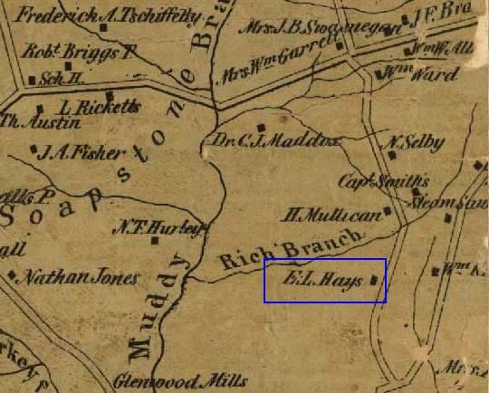 Hays' farm appears on Simon
J. Martenet's 1865 map of Montgomery County, standing
south of the road that ran from Darnestown to Rockville. His farm also
bordered the Muddy Branch to the west and the Rich Branch to the north.3 Such networks of roads and streams often aided runaway slaves in their
escapes. Although Martenet's map showed another road running north from the Potomac
River to Gaithersburg, passing close to the east side of Hays' house,
this road was laid over a decade after Brown's escape.4
Hays' farm appears on Simon
J. Martenet's 1865 map of Montgomery County, standing
south of the road that ran from Darnestown to Rockville. His farm also
bordered the Muddy Branch to the west and the Rich Branch to the north.3 Such networks of roads and streams often aided runaway slaves in their
escapes. Although Martenet's map showed another road running north from the Potomac
River to Gaithersburg, passing close to the east side of Hays' house,
this road was laid over a decade after Brown's escape.4
1. U.S. Census Bureau (Census Record, MD) for Edward L. Hays, 1840, Montgomery County, Rockville District, Pages 29 and 30, Line 30 [MSA SM61-113, M 4722]. Slaves appear on Page 30.
2. "$100 Reward." Maryland
Journal 1 October 1845: 3. MSA SC 3839, Reel M 7933. Maryland State
Archives.
U.S. Census
(Census Record, MD) for Edward L. Hays, 1840, Montgomery County, Rockville
District, Pages 29 and 30, Line 30 [MSA SM61-113, M 4722]. Slaves appear
on Page 30.
3. Montgomery County District 4, Simon J. Martenet, Martenet and Bond's Map of Montgomery County, 1865, Library of Congress, [MSA SC 1213-1-464]. The Huntingfield Map Collection.
4. MONTGOMERY COUNTY CIRCUIT
COURT, (Land Records), Liber JGH 7, Folio 603, [MSA CE 63-8]. E. L. Hays,
et al, to Commission for Montgomery County, November 24, 1859.
Return to Charles Brown's Introductory Page
|
Tell Us What You Think About the Maryland State Archives Website!
|