|
RICHMOND
BALTIMORE
289
to the economic well-being of the city. The plan of the town in 1792,
reproduced in figure 202 shows the outer limits established by the port
wardens for dock construction. It also reveals the extent to which owners
of water-front property had already taken advantage of their right to
extend piers and wharves into the original natural harbor. Ultimately
most of the intervening boat slips were to be filled and built on, and the
lines of the old docks can be recognized in the modern city only by the
closely spaced streets running southward from the present Pratt Street.
At the time of the Revolution, Baltimore could boast of a population
of nearly seven thousand persons. To Dr. Robert Honyman in 1775 it
seemed "a neat, well built place," with "streets, strait & wide," although
they appeared "much in need of paving."39 By 1795, according to that
meticulous observer, Mederic Moreau de St. Mery, the population had
more than doubled to fifteen thousand, and there were three thousand
houses, "the greater part brick and elegantly built."
Moreau de St. Mery noted with evident approval the regularity of the
gridiron street system and observed that "future streets have already been
staked out and even named." He listed the major buildings of the
growing city: the prison, three markets, the poor house, two banks, a stock
exchange, a theatre, eleven churches, and the courthouse. While he was
impressed by the growth and appearance of the town as a whole, at Fell's
Point he found "the buildings are much more modern than those in Balti-
more, and are increasing prodigiously."
This French visitor was particularly struck by the pleasant character of
the hill that rose to the north of the city. "This belongs to Colonel Howard,
whose residence and out-building are situated on the front portion. The rear
portion is beautified by a park. Its elevated situation; its groves of trees;
the view from it, which brings back memories of European scenes: all
these things together fill every true Frenchman with both pleasure and
regret.""°
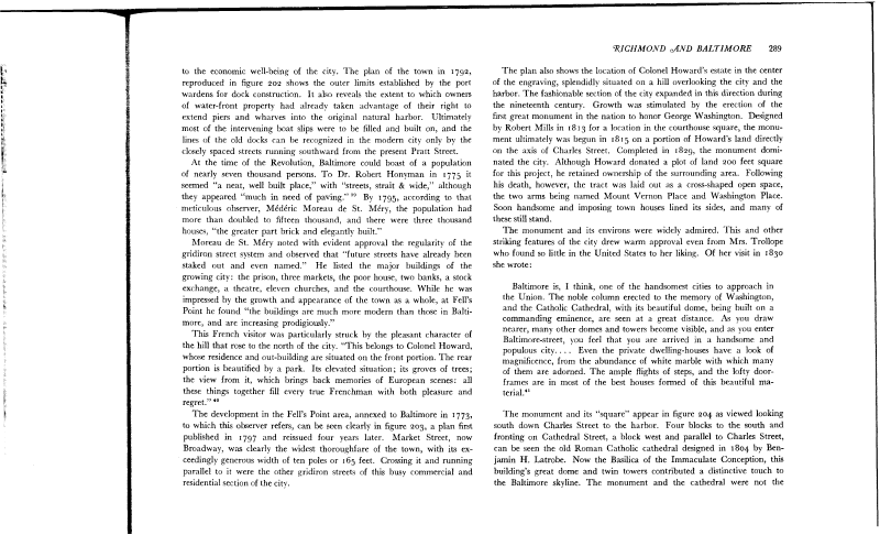
The development in the Fell's Point area, annexed to Baltimore in 1773,
to which this observer refers, can be seen clearly in figure 203, a plan first
published in 1797 and reissued four years later. Market Street, now
Broadway, was clearly the widest thoroughfare of the town, with its ex-
ceedingly generous width of ten poles or 165 feet. Crossing it and running
parallel to it were the other gridiron streets of this busy commercial and
residential section of the city.
The plan also shows the location of Colonel Howard's estate in the center
of the engraving, splendidly situated on a hill overlooking the city and the
harbor. The fashionable section of the city expanded in this direction during
the nineteenth century. Growth was stimulated by the erection of the
first great monument in the nation to honor George Washington. Designed
by Robert Mills in 1813 for a location in the courthouse square, the monu-
ment ultimately was begun in 1815 on a portion of Howard's land directly
on the axis of Charles Street. Completed in 1829, the monument domi-
nated the city. Although Howard donated a plot of land 200 feet square
for this project, he retained ownership of the surrounding area. Following
his death, however, the tract was laid out as a cross-shaped open space,
the two arms being named Mount Vernon Place and Washington Place.
Soon handsome and imposing town houses lined its sides, and many of
these still stand.
The monument and its environs were widely admired. This and other
striking features of the city drew warm approval even from Mrs. Trollope
who found so little in the United States to her liking. Of her visit in 1830
she wrote :
Baltimore is, I think, one of the handsomest cities to approach in
the Union. The noble column erected to the memory of Washington,
and the Catholic Cathedral, with its beautiful dome, being built on a
commanding eminence, are seen at a great distance. As you draw
nearer, many other domes and towers become visible, and as you enter
Baltimore-street, you feel that you are arrived in a handsome and
populous city. . . . Even the private dwelling-houses have a look of
magnificence, from the abundance of white marble with which many
of them are adorned. The ample flights of steps, and the lofty door-
frames are in most of the best houses formed of this beautiful ma-
terial.41
The monument and its "square" appear in figure 204 as viewed looking
south down Charles Street to the harbor. Four blocks to the south and
fronting on Cathedral Street, a block west and parallel to Charles Street,
can be seen the old Roman Catholic cathedral designed in 1804 by Ben-
jamin H. Latrobe. Now the Basilica of the Immaculate Conception, this
building's great dome and twin towers contributed a distinctive touch to
the Baltimore skyline. The monument and the cathedral were not the
|