Newsletter of
The Maryland State Archives
Vol. 15, No. 6
March 26, 2001
www.mdsa.net
PRIMARY SCHOOL DISTRICTS: ANNE ARUNDEL AND HOWARD COUNTIES 
by Pat Melville 
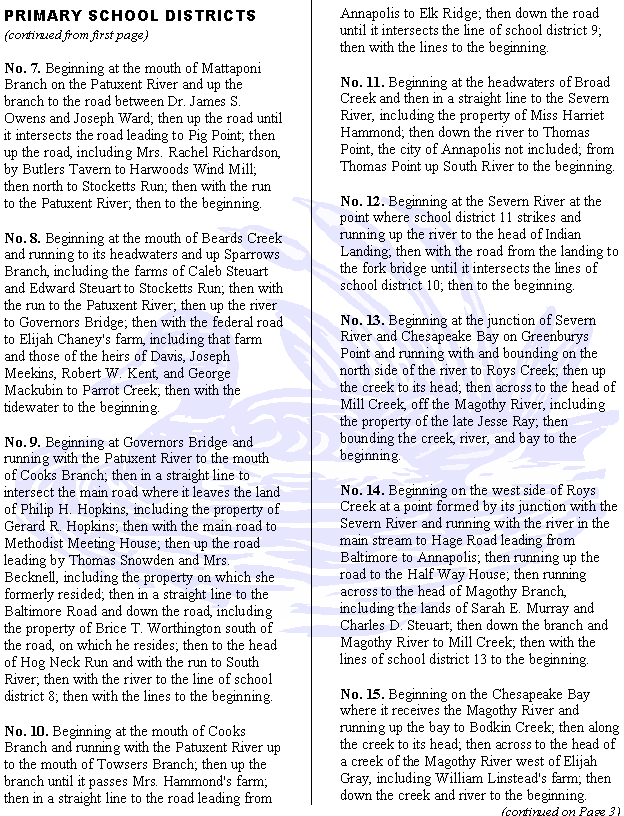
In August 1827 the Commissioners of Primary Schools for Anne Arundel County met to divide the county into school districts most of which were drawn as close as possible to a standard of five miles in length and five miles in width. The results were filed with the clerk of the court and recorded in (Land Records) WSG 13, pp. 123-129 in series C97. The commissioners numbered the districts consecutively beginning with one at the south end of the county and proceeding north through what is now Howard County. Nineteen of the thirty-seven districts are outlined in this article. The rest will be included in a future edition. The boundary descriptions also provide names of land owners, creeks and other small bodies of water, roads, and other local landmarks. Descriptions for districts 1-19: 

No. 1. Beginning at the southeastern point of the county and running west and north with the county line to Lyons Creek; then with the creek to the eastern part of the farm of Thomas J. Hall; then east by Benjamin Griffin to a small creek; then with the creek to Herring Bay; then south to the beginning. 

No. 2. Beginning at the mouth of Lyons Creek and running up the creek to a branch south of Robert Pindell's mill; then north up the branch, including the farms of Philip Darnall, heirs of John Weeks, Nicholas L. Darnall, Isaac Owens of Ben, heirs of Nicholas Owens, and James S. Owens, to Mataponi Branch; then down this branch to the Patuxent River; then down the river to the beginning. 

No. 3. Beginning at the creek south of Gustavus Weem's farm; then up the creek, including Benjamin

Griffin, to Lyons Creek; then down the creek to the first branch emptying into the creek from the north and below the farm of Gassaway Pindell; then up the branch, including the farms of Gassaway Pindell, Levi Wayson, Rezin Estep, Claudius F. Legrange, and Susanna J. Gott, to the public road leading from Annapolis to Pig Point; then up the road, including the farms of Henry A. Hall, John Thomas, Dr. Martin Fenwick, Nancy Franklin, Capt. Thomas Franklin, and John C. Weems, to the tidewater; then with the tidewater to the beginning. 

No. 4. The territory called the Swamp and farm of Judge Johns. 

No. 5. Beginning at the headwaters of West River, including Virgil Maxcy's farm, to the public road leading to Traceys Landing; then up the road by Butlers and Fogget's Tavern to Harwoods Wind Mill; then north to Stocketts Run; then up the run until it intersects Annapolis Road; then up the road to South River Church; then down the road leading to West River to the head of Muddy Creek; then with the creek to the tidewater; then with the tidewater to the beginning. 

No. 6. Beginning at the head of Muddy Creek and running with the road from the creek to South River Church; then with the road southwest to the head of Stocketts Run; then with the run to the road near Mrs. John Bird; then on a straight line to Beards Creek; then with the tidewater to Rhode River; then to the beginning. 

(continued on Page 2)


Page 2
The Archivists' Bulldog

The Archivists' Bulldog 
Page 3
PRIMARY SCHOOL DISTRICTS
(continued from Page 2)

No. 16. Beginning at the head of Bodkin Creek and running down the creek to the Chesapeake Bay; then running along the bay and Patapsco River to Stony Creek; then along the creek to its head; then with Bate Branch to its head; then in a straight line to the place where Jumpers Hole Road and Mountain Road intersect; then with Jumpers Hole Road to Magothy Branch; then down the branch and river to the creek west of Elijah Gray; then with the creek and lines of school district 15 to the beginning. 

No. 17. Beginning at the place where Jumpers Hole Road and Mountain Road intersect and running in a straight line to the head of Bate Branch; then down the branch and Stony Creek to the Patapsco River;

then with the river to Curtis Creek; then with the creek and Jumpers Hole Road to the beginning. 

No. 18. Beginning where Jumpers Hole Road crossed Magothy Branch and running with the branch and line of school district 14 to the Half Way House; then with Baltimore Road to Mrs. Cissells Tavern; then across to intersect the old saw mill branch; then along the branch, Furnace Creek, Curtis Creek, and Jumpers Hole Road to the beginning. 

No. 19. Beginning at Mrs. Cissells Tavern and running with the public road to Hammonds Bridge; then down the Patapsco River to Curtis Creek; then with the creek to Furnace Creek and old saw mill branch to Holly's old mill and then to the beginning. 

RECORD TRANSFERS

PRINCE GEORGE'S COUNTY REGISTER OF WILLS 
    (Accounts Against Deceased Estates) 1961-1972 [MSA T702] 
    (Administration Accounts) var.d. [MSA T706] 
    (Administration Accounts, Index) 1696-1971 [MSA T3252] 
    (Administration Bonds) 1967-1985 [MSA T704] 
    (Administration Bonds, Index) 1698-1971 [MSA T3254] 
    (Administration Proceedings) 1970-1979 [MSA T3251] 
    (Claims Docket) 1970-1992 [MSA T3256] 
    (Equity Record) 1861-1940 [MSA T3255] 
    (Estate Docket) 1860-1871 [MSA T3266] 
    (Estate Docket, Index) 1972-1987 [MSA T3265] 
    (Estate, Index) 1810-1971 [MSA T3253] 
    (Guardian Accounts) 1933-1999 [MSA T705] 
                                                            (continued on last page)


RECORD TRANSFERS (continued from Page 3)

    (Guardian Bonds) 1962-1993 [MSA T703] 
    (Guardianship Proceedings) 1996-1999 [MSA T3260] 
    (Inventories) 1967-1985 [MSA T699] 
    (Inventories, Index) 1696-1968 [MSA T3261] 
    (Inventories, Real Estate) 1967-1988 [MSA T710] 
    (Joint Account Record) 1952-1986 [MSA T3262] 
    (Minutes) 1970-1977 [MSA T3257] 
    (Notice to Creditors) 1970-1986 [MSA T3263] 
    (Orphans Court Proceedings) 1919-1997 [MSA T700] 
    (Receipt Docket) 1968-1985 [MSA T709] 
    (Rough Minutes) 1863-1872 [MSA T3258] 
    (Small Estate Docket) 1945-1986 [MSA T3264] 
    (Small Estate Record) 1967-1980 MSA T711] 
    (Wills) 1966-1979 [MSA T708] 
    (Wills, Index) 1698-1971 [MSA T3259] 

WORCESTER COUNTY CIRCUIT COURT 
    (Judgment Record) 1836-1891 [MSA TM614] 
    (Land Records, Index) 1876-1917 [MSA TM557] 
    (Land Records) 1742-1857 [MSA TM380] 
    (Land Records, Grantee Index) 1742-1876 [MSA TM555] 
    (Land Records, Grantor Index) 1742-1966 [MSA TM554] 
    (Mortgage Records, Index) 1914-1917 [MSA TM553] 
    (Test Book) 1897-1961 [MSA TM614]