
Publications Maps
Note: Read before ordering. Portfolios cannot be
split.
Portfolio of Maps [4 each - Price: $30] Inventory #286
Virginia Farrer, 1651 | John Ogilby, 1671 | John Thornton
& Robert Greene, 1678 | Emanuel Bowen, 1752
Portfolio of Maps [6 each - Price: $40] Inventory #101
Virginia Farrer, 1651 | John Ogilby, 1671 | John Thornton
& Robert Greene, 1678 | Emanuel Bowen, 1752 | Warner &
Hanna, 1801 | Edward Sachse, 1858
Publication Maps
[View image]
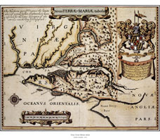 John Ogilby (1600-1676) is
probably best known for his maps of the roads of England.
As one of his biographers, Sir Herbert George Fordham,
points out, his Brtfannia, published between 1671 and
1675, effected a revolution in the manner of measuring
distance by replacing the old British mile of 2,428 yards
with the statute mile of 1,760 yards. Ogilby had a
difficult life. Twice reduced to beggary, he began anew
and recouped his fortune, ultimately obtaining the
official position of King's Cosmographer and Geographic
Printer. He included this map of Maryland in his America
(1671), accompanied by "A New Description of Mary-land
that became a standard source of geographical information
about the colony and was used for decades with and without
attribution by other authors. His map was a copy of that
published in 1635 in A Relation of Maryland, commonly
known as the Lord Baltimore Map. It contained several new
features, however, some more subtle than others. Ogilby
correctly identified the counties of Maryland then in
existence, as well as one, Cecil, that had yet to be
designated as such by the Maryland legislature. He also
carefully concealed the fact that he had moved the
northern boundary higher up the Susquehanna River than had
been the case in Lord Baltimore's 1635 original by adding
a couple of rows of trees. He undoubtedly did so with Lord
Baltimore's approval, but it proved of little help in the
later controversy with William Penn. Penn got the courts
to agree that the earlier version was more accurate.
John Ogilby (1600-1676) is
probably best known for his maps of the roads of England.
As one of his biographers, Sir Herbert George Fordham,
points out, his Brtfannia, published between 1671 and
1675, effected a revolution in the manner of measuring
distance by replacing the old British mile of 2,428 yards
with the statute mile of 1,760 yards. Ogilby had a
difficult life. Twice reduced to beggary, he began anew
and recouped his fortune, ultimately obtaining the
official position of King's Cosmographer and Geographic
Printer. He included this map of Maryland in his America
(1671), accompanied by "A New Description of Mary-land
that became a standard source of geographical information
about the colony and was used for decades with and without
attribution by other authors. His map was a copy of that
published in 1635 in A Relation of Maryland, commonly
known as the Lord Baltimore Map. It contained several new
features, however, some more subtle than others. Ogilby
correctly identified the counties of Maryland then in
existence, as well as one, Cecil, that had yet to be
designated as such by the Maryland legislature. He also
carefully concealed the fact that he had moved the
northern boundary higher up the Susquehanna River than had
been the case in Lord Baltimore's 1635 original by adding
a couple of rows of trees. He undoubtedly did so with Lord
Baltimore's approval, but it proved of little help in the
later controversy with William Penn. Penn got the courts
to agree that the earlier version was more accurate.
![[View image]](/msa/homepage/html/bookstore/ogilby_msa_sc5458_51_4494-009.jpg)
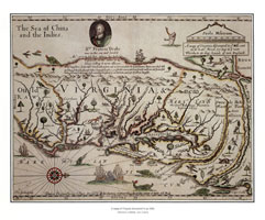
John Thornton (1641-1708) and Robert Greene (fl. 1673-78)
were printers, map sellers, and members of the Merchant
Taylors' Companyof London. John Thornton was the
betterknown map maker, although Greene apparently printed
maps for other prominent map makers, such as Robert Morden
and William Berry, and owned a "presse to Print" at his
death. This map is based upon Herrman (1673), and from it
manuscript maps may have been prepared for use by the
Lords of Trade, who were charged with overseeing the
affairs of the American colonies. It is the first detailed
map of Maryland to be oriented north and south, like
modern maps, in contrast to the maps of Captain John Smith
(1612) and Augustine Herrman (1673), which put west at the
top.
Thorton's cartouches are distinctive; crude in some
respects, but charming. This map of Maryland was so rare
that it was missed by most bibliographers and historians
of cartography; Lawrence Wroth first described it in 1943.
When it was first published is not altogether clear.
Maryland place names follow Herrman closely, but place
names for New Jersey suggest either 1676 or 1678,
depending on whether one argues that the map was
propaganda for James Wasse's surveys (1676) or was
completed on his return (ca. 1678). In either case,
Wasse's name figures prominently on the map, which exists
in three known versions. The earliest (shown here) wrongly
labels the "Schuykill River," in what was to be
Pennsylvania, as the "Hore Kill" River, a mistake that was
corrected to "Skoole Kill" in the second version. A third
issue, ca. 1685, indicated the new Province of
Pennsylvania.
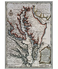
Little is known about Emanuel Bowen (fl.1714-67) except that he was appointed geographer to George I1 of England and Louis XV of France and that he died poor and nearly blind in 1767. His New and Accurate Map of Virginia was first published in 1747 in his edition of Herman Moll's Complete System of Geography. The text accompanying the map was "borrowed" from John Oldmixon's British Empire in America, first published in 1708, while the map itself was a combination of Herman Moll's Virginia and Maryland (1708) and the Maryland portion of Henry Popple's Map of the British Empire in America (1733). There are only two known versions of Bowen's map, although a misreading of Phillip's monumental study of atlases has led some to believe there are four. The edition of 1747 bears the plate number 95; that of 1752, the plate number 61. In 1752 some labels were also changed, with mixed results. For example, in 1747 Bowen erroneously called Annapolis "Arundelton," which he corrected in 1752, but then went on wrongly to replace "Anne Arundel County" with "Annapolis County."
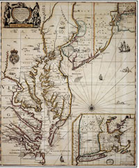
This fanciful map of Virginia and Maryland was first
ascribed to John Farrer [Ferrar], a member of the Virginia
Company, when it was published in 1651. In fact, it was
probably drawn by his daughter, Virginia, who indeed
asserted her authorship by having the original plate
altered the following year, and all subsequent printings
bear her name. Little is known about Virginia Farrer. She
lived in Little Gidding, Huntingdonshire, England, and
died a spinster there in 1687, apparently never having
visited the New World. She was an acknowledged authority
on silkworms and wrote poetry extolling the ease by which
Virginians could reach the Pacific if only they would
explore a short distance further south and west, a
misconception quite evident in her map. Her lack of
geographical knowledge is obvious, although she ought not
to be too severely criticized for reflecting what little
information was available. Not until 1673 would any major
advancement be made in the cartography of Maryland, with
the publication of Augustine Herrrnan's map. Still, Farrer
could have known that Maryland was founded in 1634 and
that one of its counties was "Anne Arundel," not
"Anandale." In all, her map is more important as
propaganda for exploration and as art than as
cartography.
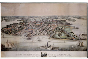
Edward Sachse (1804-73) was a noted Baltimore painter and lithographer. He came to Baltimore from Germany in the late 1840s and established E. Sachse and Company, about 1850. He printed maps, including Bond's map of Frederick County (1858), but he is best known for his scenes and "bird's-eye" views. Until publication of this print there was no detailed map of Annapolis, although a street plan had been included on the Coast and Geodetic Survey chart of Annapolis Harbor in 1846. Although Sachse had already published a view of the harbor from the dome of the State House, this is the first print to provide an overview of all the buildings in town. It is not accurate in every respect and necessarily suffers from the distortion caused by trylng to delineate buildings and yet maintain the chosen perspective. Thus, there are problems of scale as well as at least one error of fact. St. Anne's Church, to the left of the State House on Church Circle, never had twin towers. The church burned in 1858, and Sachse may have been reflecting the wishful thinking of parishioners who had to be satisfied with only one tower when the church was rebuilt.
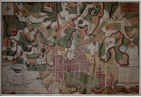
Varle published a number of maps during his career, including one of Haiti (1796), a large map of the United States (1817), and the first cadastral (landownership) map of a Maryland county (1808). One of his most delightful creations, however, was this map of Baltimore City, which, for some unknown reason, he chose not to sign. It first appeared in 1799. A contemporary, Thomas Griffith, later supplied the correct attribution in his Annals of Baltimore (1824). Varle's map of the city apparently did not do well, and he sold the copper plate to Baltimore booksellers Warner and Hanna, who published this edition in 1801 without mention of its author.
|
This web site is presented for reference purposes under the doctrine of fair use. When this material is used, in whole or in part, proper citation and credit must be attributed to the Maryland State Archives. PLEASE NOTE: The site may contain material from other sources which may be under copyright. Rights assessment, and full originating source citation, is the responsibility of the user. |
© Copyright December 15, 2023 Maryland State Archives