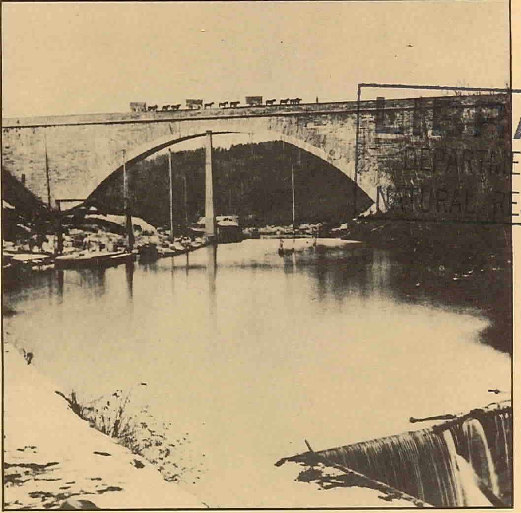
On the cover: Photograph of the Cabin John Bridge, c.
1864. The bridge was built by the U.S. Army Corps of Engineers as part
of the water supply system for the City of Washington, D.C., and is still
a functioning part of the Washington Aqueduct. The system currently withdraws
as much as 200 million gallons per day from the Potomac at Great Falls,
Maryland, and carries the water ten miles downstream for treatment at the
Dalecarlia Water Treatment Plant in the District of Columbia. The bridge
carries the aqueduct across Cabin John Creek in Maryland, and was at one
time the largest single-span stone arch in the Western Hemisphere. It is
now listed as a Civil Engineering Landmark by the American Society of Civil
Engineers. Photo courtesy U.S. Army Corps of Engineers.
LEGAL RIGHTS IN POTOMAC WATERS
PROCEEDINGS OF A CONFERENCE
AT HARPER'S FERRY, WEST VIRGINIA
Edited by:
GARRETT POWER PROFESSOR OF
LAW UNIVERSITY OF MARYLAND SCHOOL
OF LAW
Editorial Assistant:
REGINA K. WOLOSZYN
Sponsored by: INTERSTATE
COMMISSION ON
THE POTOMAC RIVER BASIN
4350 EAST WEST HIGHWAY
BETHESDA, MARYLAND 20014
and
MARYLAND DEPARTMENT OF
NATURAL RESOURCES
TAWES STATE OFFICE BUILDING
ANNAPOLIS, MARYLAND 21401
SEPTEMBER 1976 ICPRB General Publication
76-2 ACKNOWLEDGEMENTS The Interstate
Commission on the Potomac River Basin and the Maryland Department of Natural
Resources wish to express appreciation to Nathaniel P. Reed, Assistant
Secretary for Fish, Wildlife, and Parks of the United States Department
of Interior, for making available the facilities of the National Park Service's
Mather Training Center at Harper's Ferry, West Virginia, for the Potomac
Basin water law conference. Park Service personnel were most helpful in
making the symposium the success that it was. In addition, the Interstate
Commission on the Potomac River Basin is most grateful to the Maryland
Department of Natural Resources for co-sponsoring what is hoped to be the
first in a series of symposia on water rights and water law applicable
to the waters of the Potomac River Basin.
GENERAL COUNSEL'S STATEMENT As
General Counsel for the Interstate Commission on the Potomac River Basin,
it was my responsibility to organize the water law "teach-in" on May 14,
1975 at Harper's Ferry, West Virginia. The experts selected by Professor
Garrett Power and myself were picked for their expertise in the natural
resources law field, and the opinions they expressed in their papers and
during the symposium are their own. No member of the Commission, the Commission's
staff, or myself in any way endorsed or directed what was said.
I regret that despite numerous contacts with the General
Counsel's office at the Army Corps of Engineers, Baltimore District, we
were unable to secure a paper or a speaker from the Corps. However, the
top level representation of Corps officials at the conference more than
made up for the lack of a formal presentation setting forth the rights
claimed by the United States over Potomac River waters. It is hoped that
at some time the Corps will prepare a legal brief setting out U.S. rights
in the Potomac; hopefully this could be sent out as a follow-up to this
publication.
I am most grateful to John Salyer, Esq., Assistant Corporation
Counsel of the District of Columbia, for providing on very short notice
the paper covering water rights for the District of Columbia.
The dynamic interchange among agency representatives
and industrial people with the panel of experts enlightened all, and it
is our hope that this will assist in political accommodation on water rights
issues, in place of possible long and drawn-out litigation.
All the speakers at the conference were most generous
in sharing their expertise and opinions. A good start has been made in
setting out what could be called the "base-line" of water rights law in
the Potomac River Basin.
Henry P. Stetina
FOREWORD
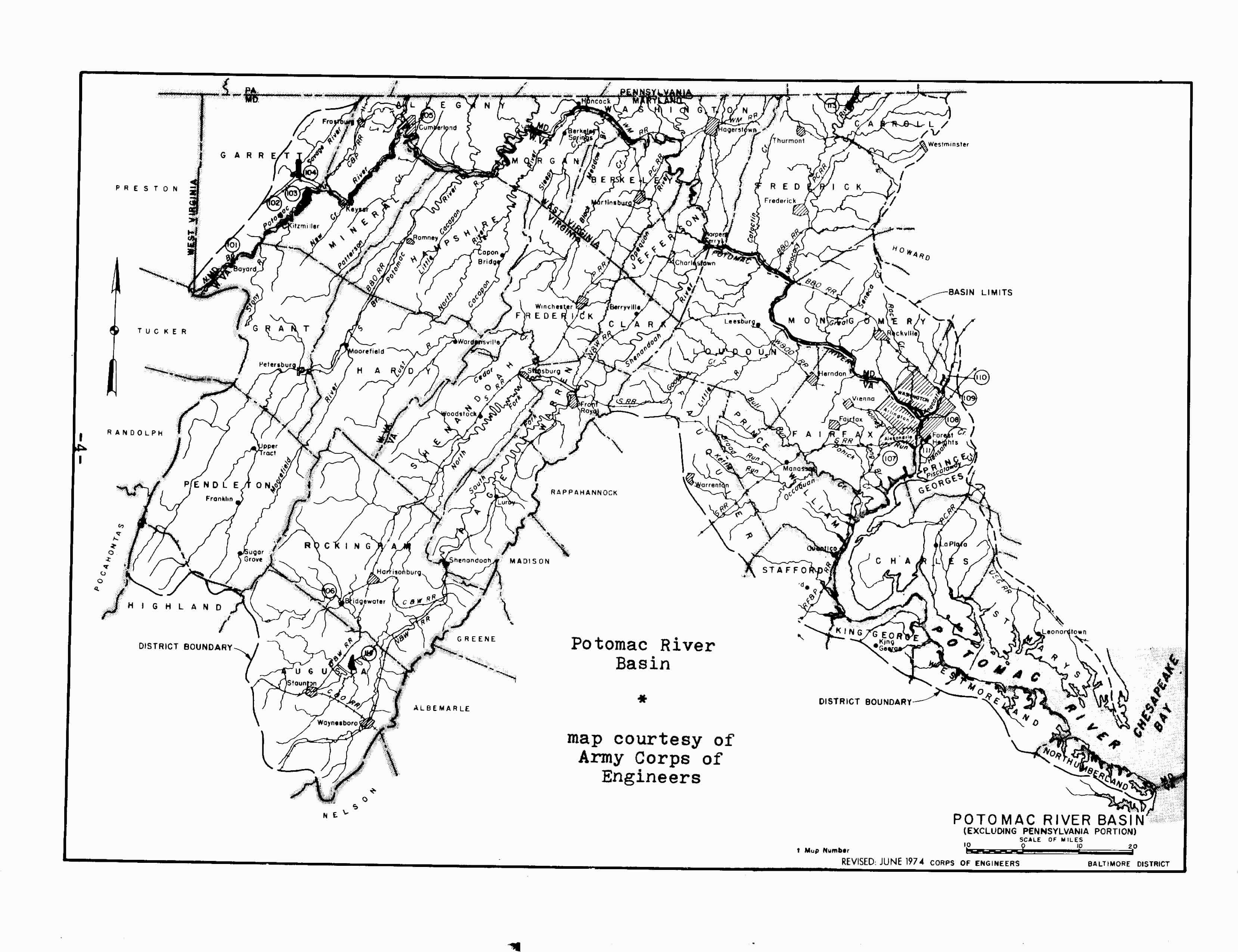
Meandering through the hills of Appalachia to the shores
of Chesapeake Bay, the Potomac River and its surrounding Basin cover 15,000
square miles of territory---including portions of West Virginia and Pennsylvania,
Virginia and Maryland, and all of the District of Columbia. The river itself,
some 400 miles in length, has for centuries been a site of recreation and
fishing and, increasingly important, a source of water.
Indeed, provision for an adequate water supply to the
sprawling Washington metropolitan area is perceived as the Basin's major
problem, one whose resolution is substantially complicated by the multiplicity
of jurisdictions concerned. The various states and the District of Columbia
have diverse laws and sometimes conflicting interests. West Virginia and
Pennsylvania presently make only minimal demands on Potomac waters, but
are in a position of advantage hydrologically, with respect to the river's
sources. For several hundred miles the Potomac serves as a boundary line
between Virginia and Maryland, but through various historical quirks and
legal interpretations, the whole river is considered within Maryland's
boundaries. Accordingly, Maryland has required the Commonwealth and citizens
of Virginia to seek its permission before making appropriations of its
water. The District of Columbia is at a peculiar disadvantage when it comes
to using the Potomac water, because the river becomes estuarine--as the
fresh water becomes with salt---before entering the District's boundaries.
-vii-
The federal government is of course likewise concerned
with the allocation of Potomac waters. Congress has ceded to the Army Corps
of Engineers specific responsibility for providing water to the District
of Columbia, in addition to the Corps' general powers as a regulator of
navigable waterways and a builder of dams.
It is against this background that a working conference
on Water Rights Affecting the Potomac Basin, sponsored jointly by the Interstate
Commission on the Potomac River Basin and the Maryland Department of Natural
Resources, was held in Harper's Ferry, West Virginia, on May 14, 1976.
The goal of the meeting was more to frame appropriate questions than to
answer them. Thus the program was designed to air differing perspectives
and to define issues---rather than to present official hard-line positions
of the jurisdictions involved.
The Proceedings which follow are a product of the conference.
The piece by Kenneth Lasson, A History of Potomac River Conflicts, provides
the historical backdrop upon which the current disputes are set. Steve
H. Hanke, in Forecasting Water Use in the Potomac River Basin, looks to
the future and predicts demands for water consumption within the Basin
area; his work also emphasizes the extent to which such demands can be
modified through alternative price strategies. Federal Authority in the
Potomac River Basin by Thomas B. Lewis outlines the federal statutory and
constitutional prerogatives. Then John Salyer, Warren K. Rich, R. Timothy
Weston, Denis J. Brion and Patrick C. McGinley look respectively to the
relevant laws and institutions of the District of Columbia, Maryland, Pennsylvania,
Virginia and West Virginia.
-viii- Taken together, the
papers pose the water supply issues facing the Potomac Basin, ranging from
general to specific: ---Is there a need for an agency with overall water
resource planning and management powers in the Potomac Basin? If so, how
should it be organized and financed? ---How should water be priced in the
Washington metropolitan area? Is the area in fact "water short"? If so,
is the problem one of base flow, peak demand, or both? ---Should the dams
and reservoirs proposed by the Army Corps of Engineers for Bloomington,
Sixes Bridge and Verona be constructed? If so, when? ---Do the States of
West Virginia and Pennsylvania have the power to divert Potomac waters
into other basins? If so, are there any legal constraints on such authority
and what are they? ---Under present law, must Virginia and the Corps of
Engineers obtain permission from the State of Maryland before appropriating
Potomac waters? If so, can Maryland prerogatives be diminished without
its consent? ---Must specific statutes of the various states be changed
in order to achieve an economically efficient allocation of water resources?
If so, which laws need be modified? The papers which follow analyze these
questions in some detail. A great deal more work may provide some answers.
September 1, 1976
Garrett Power
-ix-
PAPERS PRESENTED
BY
CONFERENCE SPEAKERS
A HISTORY OF POTOMAC RIVER CONFLICTS
Kenneth Lasson
We now know. the Potomac River as a 383-mile waterway
which forms a clear interstate boundary between Maryland and Virginia on
the one hand, and Maryland and West Virginia on the other. l
It hasn't always been that simple. Just where the Potomac is, and to whom
it belongs, have been in dispute for at least 350 years.
I. Where and Whose?
We aren't certain how the Indians divided or decided their
rights to the river, but the earliest recorded controversies over ownership
and jurisdiction arose from conflicting royal charters given to the Virginia
Company and to Lord Baltimore. The former received three successive charters
from the English Crown; all three documents extended the boundaries of
Virginia north and south of the present state, to include all of Maryland,
parts of Pennsylvania, and parts of North Carolina. The terms of the second
charter (granted by King James I on May 23, 1609) gave the Virginia Company
all territory from Point Comfort 200 miles to the north and 200 miles to
the south. 2
It was on June 20th of 1632 that King Charles I granted
to Lord Baltimore a tract of land on the Atlantic Coast of North America,
which was to become the proprietary colony of Maryland. The southern boundary
(west of the Chesapeake Bay) was specified by the charter--which was written
in Latin. Although some controversy exists over the translation, a generally
accepted version of the boundary extends
-2 -
the northern line of Maryland along the 40th parallel
of latitude, to a point where the meridian of longitude which passes through
the "first fountain" of the Potomac intersects this parallel. The meridian
thus designated forms the western boundary of Maryland.
The boundary description continues:
Unto the true meridian of the first Fountain of the
River of Pattowmack, thence verging toward the South, unto the further
bank of the said River, and following the same on the West and South, unto
a certain Place, called Cinquack, situate near the mouth of the said River,
where it disembogues [sic] into the foresaid Bay of Chesapeake. The charter
appears to grant possession of the entire Potomac to Maryland: that is,
the western boundary line of Maryland extends from the Pennsylvania border
south across the river to the "further bank"--or south shore of the river.3
Now, the King and his Council had absolute authority over
the American colonies, and they could and did change boundaries at their
royal pleasure. That the King could carve out such a large tract of land
from Virginia was not disputed, nor was his power to include in that grant
the entire Potomac. But the specific terms and intentions of the grant
have long been argued.
In the early 17th century the territory wherein the source
of the Potomac lies was unexplored wilderness. The river's length, source,
and course were unknown. If, at its source, the Potomac were headed in
a northeasterly direction before it turned to its primary southeasterly
flow, or if the Potomac extended north of the 40th parallel, it could be
contended that the terms of the grant called for the river to lie outside
of the boundaries of Maryland (see illustrations). In
-3-
addition, as one follows the Potomac inland, several
large branches emanate from the river's trunk, such as the Shenandoah (with
its South Fork and North Fork) and the South Branch. At the time it was
uncertain which one of these large branches was to be considered the Potomac
River; thus the jurisdiction over a large expanse of territory was unclear.
To add to the controversy over ownership rights, King
James II (in September of 1688) made a separate grant of the Northern Neck
of Virginia to Thomas (Lord) Culpeper, whose heir (Lord Fairfax) eventually
took possession. The royal charter specifically included the Potomac within
the grant which was bounded by: "Patawomerck Rivers . . . together with
the said rivers themselves and all the islands within the outermost banks
thereof . . ."4
But the earliest disputes involving the Potomac were not
over ownership of the river itself. There was little reason to contest
such rights. Commerce was limited. Established common law rules over navigable
rivers prevailed, permitting all interested parties access to the water.
Moreover, demand for seafood was confined to local consumption by the slow
modes of transportation at that time.
The early disputes centered more around ownership of contiguous
land that would be determined by the location of the Potomac. In the 1730's
Governor Gooch of Virginia and Lord Fairfax claimed much of the same western
territory. Maryland joined the fray by claiming all the land north of the
Shenandoah River (on the ground that it was the main branch of the Potomac
River). Virginia's Gooch contended that the Cahongartooten River was the
main branch of the Potomac and the
-5-
boundary of Maryland---giving him more land to the west
and south. 5
Maryland did not vigorously prosecute its claim, and
acquiesced in the settlement between Governor Gooch and Lord Fairfax. This
compromise resulted from an order by the King that Gooch and Fairfax appoint
commissioners for the purpose of deciding the boundary. The commission
adopted the North Branch, then known as the Cohaungoruton, as the main
stream of the Potomac River. A marker (known as the Fairfax Stone) was
planted at the first fountain of the North Branch. The designation of this
spring as the source of the Potomac was approved by the Virginia Assembly
and the King in Council in 1748.
Although this settlement established the first fountain
of the Potomac and the western boundary of Maryland, it left open the ultimate
question, ownership of the river itself.
In 1776, when the colonies were declaring their independence,
Virginia (on June 29th) adopted its first Constitution, which provided:
The territories contained within the charters
erecting the colonies of Maryland . . . are hereby ceded, released and
forever confirmed to the people of those colonies . . . with all the rights
of property, jurisdiction, and government . . . except the free navigation
and use of the rivers Potomac and Pocomoke, with the property of the Virginia
shore . . . and all improvements which have been or shall be made thereon.
Virginia thus unilaterally relinquished all claim to Maryland
lands, but reserved the rights of free navigation and use of the Potomac
and the riparian rights of the landowners of the Virginia shore.
Maryland, as might be suspected, did not accept Virginia's
claim to rights in the Potomac River. Under the Articles of Confederation,
-6-
serious friction began to develop between the two states
over navigation and use of both the Chesapeake Bay and the Potomac. Several
joint conferences in the late 1770's were unable to settle the differences
between them.
In June of 1784, theVirginia General Assembly resolved
to appoint George Mason, Edmund Randolph, James Madison, Jr., and Alexander
Henderson as commissioners, and invited Maryland to send its own commissioners
to meet and "frame such liberal and equitable regulations" as may be necessary.6
The Maryland Legislature, greatly concerned about Virginia's collecting
tolls from ships passing through the Virginia Capes of the Chesapeake,
responded with a resolution (January 18, 1785) appointing Thomas Johnson,
Thomas Stone, Samuel Chase, and Daniel of St. Thomas Jenifer commissioners,
and charging them with "settling the navigation and jurisdiction over that
part of the bay of Chesapeake which lies within the limits of Virginia,
and over the rivers Potomac and Pocomoke." 7
II. The Compact of 1785
The joint commission met at Mount Vernon in March of 1785,
and succeeded in drafting a compact which was accepted and confirmed by
the legislatures of both states. The Compact of 1785 provided substantially
as follows:
Article I. Virginia disclaimed the right to charge
tolls of vessels passing through the Chesapeake Bay Capes bound to or from
Maryland; the Chesapeake Bay was to be considered a common highway.
Article II. Maryland conferred the same privileges
on vessels trading to or from Virginia.
Article III. War vessels of either state were
to be free of all charges.
_7- Article IV and V. Commerce
between the citizens of both states in their own produce was to be permitted
subject to obtaining a permit from a naval officer.
Article VI. The Potomac River was to be common
highway.
Article VII. Riparian rights and fishing rights
were to be common to citizens of both states.
Article VIII. All laws and regulations for the
preservation of fish, navigation, and quarantine were to be made with the
consent of. both states.
Article IX. The expense of maintaining navigational
aids on the Chesapeake and Potomac was to be shared by both states.
Article X and XI. Both states were to have concurrent
jurisdiction over criminal and civil matters on the Potomac.
Article XII. Citizens with property in both states
had liberty to transport their produce duty free.
Article XIII. The Compact was to be confirmed
and ratified by the legislatures of both states and never to be repealed
or altered by either without the consent of the other.
The Compact of 1785 succeeded in laying the groundwork
for cooperation between Maryland and Virginia concerning the regulation
of activity on the Potomac River. But the ownership of the river remained
unresolved. Maryland still claimed rights to the high-water mark on the
south shore; Virginia claimed to the center of the river. 8
Without deciding the boundary, Article VII ("The citizens of each state
respectively shall have full property in the shores of Patowmack river
adjoining their lands") limited Maryland's claim to the low-water mark
of the Virginia shore.
During the next hundred years, in continuing attempts
to settle
-8-
the boundary, numerous resolutions were passed and commissions
created by both Maryland and Virginia---sometimes acting individually and
sometimes together. Perhaps any urgency to establish the exact boundary
between the states was diminished by the apparent effectiveness of the
Compact of 1785 in providing a stable administration over the river. Besides
the Compact, Virginia and Maryland were cooperating on improving the navigation
of the upper Potomac. They jointly chartered the Potomac Company, and its
successor, the Chesapeake and Ohio Canal Company. 9 But ownership
rights were still sought and unresolved. In 1795 the Maryland General Assembly
nominated William Pinkney, William Cooke, and Philip B. Key to serve as
boundary commissioners. 10 This overture, as well as similar
efforts in 1801 and 1810, met with little success. Once again, in 1818,
the Maryland Legislature attempted to establish a joint commission to resolve
the boundary controversy. The Virginia Assembly responded four years later,
in 1822. But a divergency in the instructions given the commissioners from
the two states led to a breakdown in negotiations which proved fruitless.
In 1825, a Maryland act which proposed that the Governor of Delaware serve
as an umpire went unreciprocated. An 1833 act of the Virginia Assembly
was ignored by Maryland. 11
Not until 1856 did a joint Maryland/Virginia commission
actually begin to negotiate. With this commission still in being, the Virginia
General Assembly passed a resolution on March 10, 1860, for Governor Letcher
to send Colonel McDonald to England, for the purpose of securing evidence
by which the true boundary between Virginia and her neighbors could be
established. Colonel McDonald visited England, and
-9-
returned with nine volumes of manuscripts and one book
of rare maps. The Civil War brought an end to this attempt to define the
true boundary.
III. The Black-Jenkins Award
A joint commission was re-established in 1872, but it
was disbanded in 1873 without success. 12 Finally, in 1874,
the two states, hoping to avoid having the boundary question determined
by the United States Supreme Court, agreed to submit to binding arbitration.
The states selected two arbitrators who in turn selected a third. The former
two were Jeremiah S. Black of Pennsylvania---a former Chief Justice of
the Pennsylvania Supreme Court and the United States Attorney General and
Secretary of State under President Buchanan ---and William A. Graham of
North Carolina, a former Governor and United States Senator. They chose
Charles J. Jenkins, a former Governor of Georgia and Justice of the Georgia
Supreme Court, as the third referee. When Graham died, Black and Jenkins
were reappointed, and James B. Beck of Kentucky was added.
The states were represented before the arbitrators by
counsel, who presented arguments. Maryland again claimed the Potomac River
to the high-water mark on the south shore; Virginia claimed the river to
the north shore. Unanimously, the arbitrators found that the Potomac River
belonged to Maryland as far as the low-water mark on the south shore. They
prepared a map and an award which described the boundary in part:
Beginning at a point on the Potomac River where
the line between Virginia and West Virginia strikes the said river at the
low-water mark, and thence following the meanderings of said river by the
low-water mark to Smith's Point, at or near the mouth of the Potomac .
. . .
-10-
The arbitrators had based their award on the original
charter to Maryland, which they thought included the Potomac River to the
high-water mark. However, by prescription, Virginia's continued use and
jurisdiction over the land on her shore to the low-water mark from the
time she first occupied the territory, should give it rights in the land
on its shore to the low-water mark. The arbitrators' assignment did not
end with determining the boundary on the Potomac, but extended across the
Chesapeake Bay to the Eastern Shore. To the award presented on the Eastern
Shore, Beck dissented. The award of the majority was approved by the legislatures
of both states and has come to be known as the Black-Jenkins Award of 1877.13
In 1899, differences arose as to the boundary in the vicinity
of Hog Island, which Maryland claimed as part of the Potomac. Governor
Lee of Virginia and Governor Jackson of Maryland requested assistance from
the United States Coast and Geodetic Survey, which assigned Henry L. Whiting
to make a determination. Whiting concluded that the lowwater line should
not follow the indentations of creeks and bays, but should run from headland
to headland. By this reasoning, Hog Island did not lie in the Potomac,
but "on" it; it was an island, by virtue of its being bounded on one side
by the Potomac and on its other sides by inland creeks. Whiting's decision
that the island belonged to Virginia reaffirmed the Award of 1877.14
IV. The Mathews-Nelson Survey
The last vestige of controversy, surrounding the indentations
along which the boundary did not run, was eliminated by the MathewsNelson
Survey of 1928. Except for several very minor deviations,
-11-
this survey reaffirmed the Award of 1877. It was approved
by the legislatures of both states (Virginia ACTS ch. 477 of 1928 and Maryland
ACTS ch. 50 of 1929).
V. Maryland Versus West Virginia
When West Virginia broke away from Virginia during the
Civil War, it succeeded to the rights and obligations of Virginia in the
Potomac River. The status of West Virginia's Potomac border with Maryland
was still as unclear as Virginia's had once been. In 1910, Maryland and
West Virginia found themselves arguing in front of the United States Supreme
Court to determine the boundaries between them. In its Bill in Equity,
Maryland claimed that her territories extended to the south shore of the
South Branch of the Potomac, rather than the North Branch as determined
by the Fairfax Stone in 1746. West Virginia answered that Virginia has
asserted and exercised jurisdiction over the territory south of the Fairfax
Stone---at the North Branch---from 1746 until 1852, when Maryland had asserted
a claim to the first fountain of the South Branch. Furthermore, argued
West Virginia, the geographical features of the river indicate that the
North Branch is the main stream of the Potomac. At the juncture of the
North and South Branches, the course of the North Branch runs straight
prior to and flowing from the juncture. The South Branch, on the other
hand, joins the river at an angle. The flow of the North Branch is more
dominant than the South Branch.
Maryland did not press this point with the Court. Its
main concern was the location of the first fountain of the North Branch
of the Potomac. Maryland rejected the theory that Fairfax Run (as designated
-12-
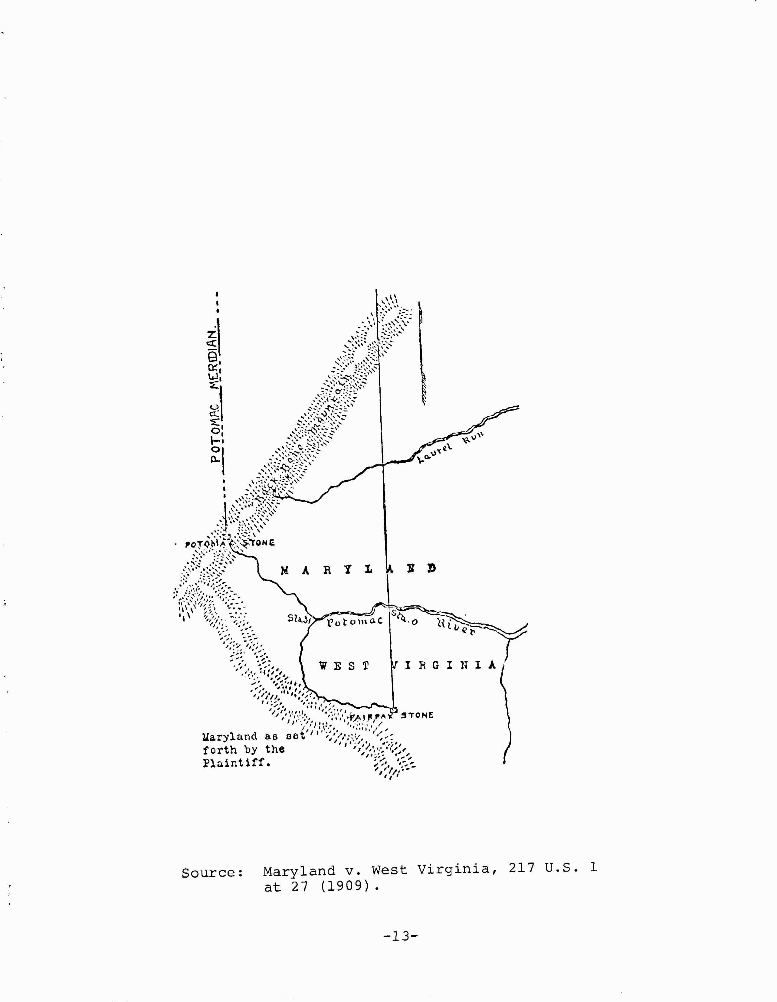
by the Fairfax Stone) was the first fountain of the North
Branch; it contended that Potomac Spring, which had just recently been
discovered, was the true first fountain. Maryland argued that the course
of Potomac Spring was more consistent with the general course of the river
than Fairfax Spring, and that Potomac Spring flowed year-round, whereas
Fairfax Spring tended to slack off during dry periods. As the source of
Potomac Spring was about one and one-quarter miles to the west of the Fairfax
Stone, a determination that Potomac Spring was a point on the Maryland/West
Virginia border would shift a tract of West Virginia land one and one-quarter
miles by 37 miles into Maryland's jurisdiction.
The Supreme Court held that the border should remain as
fixed by the Fairfax Stone. Although Maryland had not been a party to the
dispute which led to the erection of the Fairfax Stone, it had recognized
the stone as a boundary marker. When Garrett County was created in 1872,
Maryland had designated the Fairfax Stone as the southwest point of the
county. (See Maryland v. West Virginia, 217 U.S. 1 [1910].)
West Virginia claimed ownership of the Potomac River on
the basis of Lord Culpeper's grant of the Northern Neck (supra page 2).
The Court held that West Virginia's claim was ineffective in light of the
Arbitration Award of 1877. In a supplementary opinion, the Court held that
the boundary on the Potomac should be the low-water mark of the south shore
as determined by the Award of 1877. (See 217 U.S. 577, 587.)
-14- VI. The District of
Columbia
When Maryland and Virginia ceded part of their territory
to the federal government for the District of Columbia,15 they
necessarily included their respective rights in the Potomac River. 16
At that time, the District had rights to both sides of the Potomac. But
in 1846 the United States returned the land ceded by Virginia to the state,
17
opening
again the question of the exact border between the District and Virginia.
The issue was settled by judicial decisions involving private parties.
VII. Judicial Interpretation of the Compact of 1785
Criminal jurisdiction on the Potomac River, for example,
was determined to vest in the local courts of either Virginia or the District,
and not with the federal government. In Ex parte Ballinger, 88 F.
781 (D. Va. 1882), the defendant was charged in federal court with the
crime of piracy for the act of robbing a passenger on a ferryboat between
the District and Alexandria. Although the crime was committed on tidewater,
the court held that where tidewater is already under the jurisdiction of
local courts, federal courts have no jurisdiction. The defendant was discharged
on a writ of habeus corpus.
In Marine Railway & Coal Co. v. United States, 257
U.S. 47 (1921), the United States had conducted a dredging operation to
improve the channel for navigation. A sea wall was built on the riverbed
between two headlands of a shallow cove on the Virginia side of the river
adjacent to the City of Alexandria. The material dredged was deposited
behind this wall and created a new strip of land abutting land, formerly
riverfront land, owned by the Railway. The government erected a fence
-15-
separating the newly made land from the original land.
The Railway removed the fence and claimed the new land as its own. The
Supreme Court held that the United States (District of Columbia) held title
to the land beneath the water and retained title to that land when it was
reclaimed. The Court distinguished this newly reclaimed land from the reclaimed
land upon which many city blocks of Alexandria rest and to which Virginia
by long-standing occupation and administration has acquired jurisdiction
by prescription. The Court said it was immaterial that the Railway lost
its riparian rights, because riparian rights are subject to navigation
and projects necessary for navigation have priority.
In Herald v. United States, 284 F. 927 (App. D.C. 1922),
the defendant was convicted of unlawfully fishing with a dip net in the
Potomac River within the District of Columbia. He had operated his net
as he stood on the rocks between the high-water and low-water marks of
the Virginia shore. Affirming the conviction, the Supreme Court held that
the royal grant from Charles I to Lord Baltimore established the true boundary
on the Potomac to be the high-water mark. The Court declared that the Award
of 1877 between Maryland and Virginia did not affect the boundary of the
District.
The defendant in Herald also argued that regardless of
the boundary, the Compact of 1785 secured to him the right to fish in the
Potomac unless Virginia consented to the law prohibiting or regulating
fishing. The Court held that the Compact was not effective between the
District and Virginia. When the District held the land on both sides of
the Potomac, the Compact was perforce abrogated. The recession by the
-16-
United States to Virginia of its land bordering the Potomac
did not revive the Compact, for the U.S. never assented to its terms. A
similar result was reached in Evans y. United States, 31 App. D.C. 544
(1908) under a similar set of facts.
In Smoot Sand & Gravel Corp. v. Washington Airport,
Inc., 283 U.S. 348 (1931), rev'g.,44 F.2d 342 (4th Cir. 1930), the United
States Supreme Court agreed that the boundary between the District and
Virginia was at the high-water mark on the Virginia shore. This decision
allowed the Smoot Corporation to continue excavating to the highwater mark
of land claimed by the Airport. The Court reasoned that Maryland conveyed
to the District of Columbia the land to the highwater mark which the King
had granted to Lord Baltimore, and that nothing had occurred to change
that grant. The Court said that the decision in Maryland v. West Virginia,
supra, which was based on prescriptive rights, was not applicable to this
case.
Although the high-water mark is the recognized boundary
between the District and Virginia, in the vicinity of the harbor of Alexandria,
the fluctuations of the river height on vertical sea walls and piers have
no effect on the horizontal boundary. Therefore, Congress designated the
boundary in the City of Alexandria to be the established pier line. The
boundary will change as the pier line changes. 18 When the United
States sued to "quiet title to land to all fast and submerged lands . .
. that lie along the waterfront of the city of Alexandria," the Federal
District Court dismissed the action for lack of jurisdiction over land
not within the boundaries of its district
(which lies within the District of Columbia). United
States v. Herbert Bryant, Inc., 386 F. Supp. 1287 (D.D.C. 1974).
-17-
The Mount Vernon Conference which had produced the Compact
of 1785 between Maryland and Virginia was held under such cordial and cooperative
conditions that a regional conference was proposed to discuss problems
that concerned several of the middle-Atlantic and southern states. The
result of this proposal was the convention in Philadelphia that drafted
a new Constitution for the United States. Adoption of the Constitution
rendered several of the clauses of the Compact of 1785 as either ineffective
or subject to the Constitution. Section 8 of Article I gave Congress the
power to regulate commerce among the several states. Section 9 of Article
I prohibited one state from imposing duties on vessels bound to or from
another state.
Except for those constitutional limitations, however,
the Compact remained in full force and effect until it was superseded by
the Compact of 1958. In 1894, the United States Supreme Court in a lengthy
dictum in Wharton v. Wise, 153 U.S. 155, aff'g. sub nom. Ex parte Marsh,
57 F. 719 (E.D.Va.), declared that the Compact was binding on the States
of Maryland and Virginia. Nevertheless, the Compact in the instant case,
which involved a Maryland oysterman prosecuted in the Virginia courts for
violating a Virginia law in the Virginia portion of the Chesapeake Bay,
was of no effect. The Court heard arguments that the Compact violated both
Article 6 of the Articles of Confederation (which had provided that the
consent of Congress was required before any state could enter into a "treaty,
confederation, or alliance") and Section 10, Article 1 of the United States
Constitution (which requires Congressional consent before a state may "enter
into any agreement or compact with another State"). The Court said
-18-
that these provisions were directed toward the "formation
of any combination tending to the increase of political power in the States,
which may encroach upon . . . the just supremacy of the United States."
The Compact of 1785 was not of such a nature. In any event, the Constitutional
provision referred only to future compacts and agreements, not to existing
compacts. Furthermore, the two states still considered the Compact effective,
for the 1874 Acts of b.oth states designating the arbitrators of the boundary
reserved all rights and privileges granted by the Compact of 1785.
Although the citizens of Maryland and Virginia were subject
to all of the obligations and entitled to all of the benefits of the Compact
of 1785, the states, and not the people, had been parties to the Compact.
This fact was important in deciding City of Georgetown v. Alexandria Canal
Co., 37 U.S. (12 Pet.) 91 (1838). The Alexandria Canal Co. in accordance
with a Congressional charter, began the construction of an aqueduct across
the Potomac immediately above Georgetown, whose officials claimed that
the construction impaired the rights of free navigation secured to their
citizens by the Compact of 1785. The Supreme Court held that when Maryland
and Virginia ceded territory to Congress for the District of Columbia,
Congress acquired the power to do what Maryland and Virginia could do by
their joint will. As Maryland and Virginia by joint action could modify
or even abrogate the Compact of 1785, so too did Congress now have the
same power. An Act of Congress gave the Canal Company the authority to
construct the aqueduct across the Potomac. As long as the company does
not exceed this authority, it may continue its operations.
-19 VIII. Fishing Rights
and Oyster Wars
Although the Compact plainly regulates the relationship
between Maryland and Virginia concerning the Potomac River, the scope of
the document as it relates to the citizens of each state has been questioned.
In 1926 a resident of West Virginia was convicted by a Maryland court for
fishing with a fish pot in violation of the provisions of a Maryland statute
that prohibited fish pots above tidal waters. West Virginia had not consented
to this provision. The defendant raised Article VIII of the Compact which
requires all laws and regulations concerning the preservation of fish on
the Potomac to be approved by both states. The Maryland Court of Appeals
in Middlekauff v. Le Compte, 149 Md. 621, 132 A. 48 (1926), held that the
Compact did not extend to the upper, non-navigable portions of the Potomac.
The Court based its opinion on the history of the origin of the Compact,
which had been spawned in an effort to solve navigational problems. The
Court followed the famous Binney's Case, 2 Bland 99 (Md. Ch. 1829), which
held that the various terms of the Compact referred only to the navigable
waters of the Potomac.
This interpretation of the Compact has continued to the
present day. However, after two West Virginia fishermen were fined for
fishing in the Potomac without Maryland licenses in 1937, the Governor
of West Virginia protested that the Compact of 1785 gave West Virginia
residents the right to fish in the Potomac. Maryland responded that the
Compact applies only to navigable waters. A conference of the Maryland
and West Virginia governors, where Maryland proposed to allow West Virginia
residents the right to fish in the Potomac in exchange
-20-
for the right of Maryland residents to fish in the first
half-mile of the Potomac's tributaries, would not settle the dispute. West
Virginia urged taking the matter to the United States Supreme Court, but
agreed that the fishing fines here would not make for a suitable test case.
19
In the decree settling the boundary dispute between Maryland
and West Virginia, the Supreme Court had indicated that nothing was to
be construed as abrogating the Compact of 1785 which was applicable to
West Virginia. Maryland v. West Virginia, 217 U.S. 577, 585 (1910). The
applicability of the Compact to West Virginia, however, is weakened by
Maryland's Compact of 1958 with Virginia.
Maryland courts have ruled that where the Compact is applicable,
Virginia's consent to fishing laws is a prerequisite to enforcement. In
State v. Hoofman, 9 Md. 28 (1856), a man was indicted for fishing with
gill nets in the Potomac River contrary to a Maryland statute. His demurrer
was sustained on the basis that Virginia had not consented to this law
in accordance with the Compact of 1785. Maryland argued that acquiescence
by Virginia was tantamount to consent, and that Virginia had not complained
about Maryland's enforcement, but those arguments were considered insufficient
to reverse the trial court.
The concurrent jurisdiction over the fishing laws on the
Potomac carried with it the right to enforce those laws. A Maryland citizen
had been convicted by a Fairfax County, Virginia court of violating a fishing
provision of the Virginia Code that had been approved by Maryland. He had
been apprehended opposite Indian Head, Maryland, near the Virginia shore.
He argued that Article X of the Compact, dealing
-21-
with crimes and offenses on the Potomac, provided that
citizens of Maryland charged with criminal offenses were to be tried in
Maryland courts---Virginia citizens, in Virginia courts. The Supreme Court
of Virginia held in this case (Hendricks v. Commonwealth, 75 Va. 934 [1882])
that Article VIII applied to the enactment and enforcement of fishing laws,
and that Article X applied to general criminal jurisdiction that was not
specifically covered elsewhere in the Compact.
The right of a Virginia citizen charged with a criminal
offense on the Potomac to be tried in his home state has likewise been
eliminated. In Barnes v. State, 186 Md. 287, 47 A.2d 50 (1946), cert. denied,
329 U.S. 754,20 a Virginia citizen was convicted in the Prince Georges
County Circuit Court of raping another Virginia citizen on a steamboat
on the Potomac. The defendant appealed, challenging the trial court's jurisdiction.
He argued that Article X of the Compact of 1785 provided that only Virginia
courts could try a Virginia citizen for a crime committed on the Potomac.
The Maryland Court of Appeals re-examined the history behing the Compact.
It recalled that in 1785 boundary disputes between Maryland and Virginia
had given rise to a conflict of jurisdiction over the Potomac River, Maryland
claiming all of the river and Virginia claiming to the center. However,
the boundary settlement of 1877, establishing that Maryland owned all of
the Potomac to the low-water mark on the Virginia shore, vested full and
exclusive criminal jurisdiction over the Potomac in Maryland. Maryland's
claim to full and exclusive criminal jurisdiction was further supported
by the state's enactment of laws dealing with offenses on Potomac steamboats;
Virginia has
-22-
passed no such laws. The provisions in Article X for concurrent
criminal jurisdiction apply only in areas of uncertain jurisdiction, doubts
which have been few and far between since the Black-Jenkins Award of 1877.
The riparian rights granted by Article VII of the Compact
of 1785 to the owners of riverfront property belong to both Maryland and
Virginia landowners. In Bostick v. Smoot Sand & Gravel Corp. 260 F.2d
534 (4th Cir. 1958), rev'g. 154 F. Supp. 744 (D. Md.), the Smoot Corporation,
with permits from both the Army Corps of Engineers and the Maryland Board
of Public Works, began dredging operations in front of land owned by Virginia
residents. Although there is no common law right of riparian owners to
the sand and gravel below the low-water mark, Maryland by statute had granted
to riparian owners the exclusive right to remove subsurface minerals between
the high-water mark and the outer channel, so long as they did not interfere
with the fish and oyster laws. The court found that the Smoot Corporation
was, therefore, operating in violation of the riparian owners' rights,
which were also applicable to Virginia landowners.
In a dictum in Ex parte Marsh (supra, at 723), the court
remarked: "There are oysters in the more brackish waters near the mouth,
but the oyster interests of the Potomac have always been very inconsiderable."
The scarcity of oysters on the Potomac kept conflicts among the various
Chesapeake Bay oyster factions at a minimum.
In the 1870's and 80's, however, skirmishes broke out
between the tongers and the dredgers on the Potomac. 21 This was not just
a dispute between Marylanders and Virginians. The controversy involved
-23-
rivermen on the one hand, and Virginians, "Easternshoreners",
and Baltimorians on the other. The primary reason for the termination of
this "oyster war" was probably the river's dwindling supply of oysters.
The oyster industry on the Potomac continued relatively
peaceful until the end of World War II. Skyrocketing oyster prices renewed
the interests of outsiders in the Potomac oyster beds. Intense industrial
activity during the war, luring watermen away from oystering, had allowed
the oyster beds to replenish themselves. Maryland and Virginia have long
had substantial differences of opinion on how oystering should be conducted.
Virginia believes in the long-term leasing of oyster beds for exclusive
exploitation---by any method of harvesting. Maryland believes in public
beds, which can be harvested by tonging only. But Virginia power dredgers
frequently conducted illicit dredging operations.
In 1945 Virginia refused to join Maryland in a special
joint committee to study and examine the Potomac oyster problem. 22 No
agreement, as required by Article VIII of the Compact of 1785, could be
reached concerning the regulation of oystering on the Potomac. In 1950
a Maryland decision to begin bringing Virginia violators to trial in Maryland
courts brought a strong protest from the Governor of Virginia. A shooting
war erupted between Maryland's Tidewater Fisheries Commission Police and
the Virginia dredgers. The shootings, combined with a new Maryland policy
of imposing an export tax on Virginia oystermen (which Virginia claimed
violated the Compact), led to a deterioration of relations between the
two states and of the effective administration of the laws governing the
operations on the
-24-
river. Maryland accused Virginia of violating the Compact
by not prosecuting oyster offenders. 23
In 1957 Governor Theodore McKeldin signed a bill passed
by the Maryland Assembly to abrogate the Compact.24 Virginia
immediately appealed to the Supreme Court of the United States, which referred
the case to Stanley F. Reed, the retired Justice, for
settlement. (See Virginia v. Maryland, 355 U.S. 946 [1958],)25
Under Justice Reed's auspices, a new agreement (to be
known as the Potomac River Compact of 1958) was drafted. 26
This agreement specifically superseded the Compact of 1785. It also provided
that Virginia must recognize Maryland as the owner of the Potomac River
as laid out in the Mathews-Nelson Survey of 1927, that all existing riparian
rights of Article VII of the 1785 Compact are to be preserved, and that
a Potomac River Fisheries Commission (PRFC) was to be created.
The Compact of 1958 outlined the organization, power,
and authority of the PRFC, which has territorial jurisdiction over the
Potomac River from the Chesapeake Bay to the D. C. line, as well as jurisdiction
over the taking of all finfish, crabs, oysters, and clams. The PRFC is
composed of three commissioners from each state. The PRFC will make no
distinction between Maryland and Virginia residents. Maryland and Virginia
are to enforce jointly the regulations of the PRFC.
Maryland's watermen lobbied against approval of the new
Compact as a relinquishment of the state's control over the river. The
Maryland Assembly approved the Compact, but the watermen were able to force
a state-wide referendum. After the voters approved the Compact, the watermen
challenged the referendum in court. They lost. In Dutton v.
-25-
Tawes, 225 Md. 484, 171 A.2d 688 (1961), the Maryland
Court of Appeals held that minor, unintentional irregularities of publication
were not enough reason to overturn the referendum, and that making a Compact
was not an unconstitutional legislative abdication, but an exercise of
government.
Shortly after the PRFC was established, the Baltimore
Sun (on January 10, 1964) reported that Virginia was dominating the agency.
Governor Tawes called in and criticized Maryland's three commissioners
for allowing the PRFC's temporary headquarters in Virginia to take on the
appearance of a permanent headquarters---to the detriment of Maryland watermen
who must go there to obtain licenses---for letting all funds of the PRFC
to be deposited in a Virginia bank, and for permitting Virginia to supply
less than half the number of patrol boats
as Maryland. Three months later, the Sun reported that
the equities were being resolved: negotiations had started with the court
clerks of St. Marys and Charles Counties to issue PRFC licenses, all funds
from Maryland were being deposited in a Maryland bank, and Virginia agreed
to expend more money to provide patrol boats.27
PRFC regulations and licenses were given judicial approval
by the Maryland Court of Appeals in Brown v. Bowles, 254 Md. 377, 254 A.2d
696 (1969). A 1929 Maryland statute had awarded Brown, as a riparian owner
of tidelands, the first right to stake out an area in front of his property.
Bowles, holding a haul seine license issued by PRFC, continually fished
in the area claimed by Brown, who brought a suit in equity to enjoin Bowles
from fishing there. Bowles argued that the 1929 statute, to which the Virginia
Legislature had not consented, was
-26-
not valid on the Potomac River. The Court accepted Bowles'
argument, but it placed greater reliance upon a public policy argument
that if Brown were to prevail, the PRFC's regulations would be severely
limited if its powers could be preempted by riparian owners.
IX. Environmental Problems
One use of the Potomac River where a great deal of interstate
controversy might be expected is relatively free of judicial activity and
other reported disputes. This use is in the area of water supply and waste
disposal. Perhaps the paucity of reported conflicts is due to the recent
emergence of pollution and water shortage as serious problems. In 1750
the flow of the Potomac provided as much pure water as anyone then could
imagine using. By 1863 soil pollution became a problem. But not until the
early 1900's did domestic sewage and industrial pollution become serious.28
Nevertheless, the volume of the flow was adequate, even if the quality
was poor. The environmental philosophy at that time did not seek prevention
of pollution at its source. The local jurisdictions that used the Potomac's
water provided their own filtration and treatment plants, without dissension
from others. 29
As the pollution problem became increasingly serious,
or at least more recognized, the states concerned formed an interstate
commission to deal with the problem. The Interstate Commission on the Potomac
River Basin (ICPRB) was created by a compact in 194030 upon
the urging of the Rivers and Harbors Committee of the Washington Board
of Trade. This Commission included members from Maryland, Virginia, West
Virginia, Pennsylvania, the District of Columbia, as
-27-
well as the President of the United States. The role of
the Commission was largely advisory and educational, with very limited
powers.
By 1965 the limitations of the ICPRB had become apparent.
Executives of the four states and the District met and created a Potomac
River Basin Advisory Committee to draft a framework for an organization
to provide planning, management, development, and utilization of the water
resources of the Potomac River. The Committee recommended that a Potomac
River Basin Commission supersede the ICPRB, with wider powers to deal with
abatement and control of water pollution, prevention of floods, promotion
of sound watershed management, supply of water for residential, agricultural,
and industrial needs, and management of riverside beauty and water-based
recreational needs. Maryland and Virginia adopted the compact, 31
but West Virginia and Pennsylvania rejected it. 32 Pennsylvania,
already a member of two interstate river compacts, wished to avoid undertaking
the increased personnel and financial obligations that supporting a more
powerful commission would entail. As it happened, increased federal involvement
with the affairs of the river has lessened the need for an encompassing
commission as proposed.
Maryland's jurisdiction over the Potomac River has given
the state control over the diversion of large quantities of water. In May,
1974, the Potomac Basin Reporter, a publication of the ICPRB, reported
that the Maryland Water Resources Administration had issued a permit to
Fairfax County to withdraw 15 mgd of Potomac water; the amount had been
reduced from an original 32 mgd request, after several Washington-area
jurisdictions had voiced objections.
-28-
Control of the Potomac's ecology requires more than control
over the river. Regulation of the entire surrounding watershed is necessary.
In September, 1973, the State of Virginia, which was joined by the Federal
EPA and the District of Columbia, filed suit in a United States district
court against the Washington Suburban Sanitary Commission (WSSC), on whose
behalf Maryland intervened. The WSSC operates the water supply and sewerage
systems in Montgomery and Prince Georges Counties, the two Maryland counties
which adjoin the District of Columbia. In 1970 the WSSC, the District,
and Virginia counties agreed to share the facilities of an expanded sewage
treatment plant at Blue Plains in the District. In the suit, Virginia charged
Maryland with exceeding her allotment of sewage flow to the exclusion of
other jurisdictions. Virginia sought a halt to all new sewer connections
in the Blue Plains service area of Maryland. Maryland's alleged indulgence
was especially irritating to Virginia in light of a restrictive sewer moratorium
that had been imposed in Fairfax County. The suit was settled by a "Blue
Plains Treaty", which was to be submitted as part of a consent decree.
The agreement33 designated an allocation of sewage flow and
sludge disposal.
In October of 1974 Maryland filed suit against the First
American Land Corporation and its development, Yogi Bear's Jellystone Park,
located in Falling Waters, West Virginia, in the Circuit Court of Washington
County. Maryland had thus sought to control a corporation outside its territory
and not doing business within Maryland, to enforce the state's environmental
control laws. The defendant (which had a construction permit from West
Virginia) was charged with
-29-
discharging inadequately treated sewage directly into
Maryland's Potomac. This action was settled by a consent decree in December,
1974.
X. Contemporary Disputes
Pollution is not the only environmental concern likely
to provoke disputes. The preservation of the natural beauty of the river
can usually be counted on to elicit differing views about any given proposal.
In 1961 Congress empowered the Secretary of the Interior (P.L. 87-362)
to acquire and administer certain lands in Prince Georges and Charles Counties,
Maryland,opposite Mount Vernon, in order to maintain the historic and scenic
values of the area. 34 The law was passed in response to a proposed sewage
disposal plant on the opposite shore in close proximity to Mount Vernon.
The Congressional action received wide support from civic and environmental
groups, but it was opposed by developers and several local landowners.
The composition of the factions on each side of a dispute, as usual, crossed
state lines. (Today, it seems that when one's interests are no longer closely
tied to his place of residence, the contestants in a dispute are more likely
to line up as "environmentalists versus developers" rather than Marylanders
versus Virginians.) The law (P.L. 87-362) was emasculated the following
year when Congress failed to provide funds for its implementation. 35
The propensity of citizens to align themselves according
to their economic interests rather than with their state of residence is
not new. During the late 1700's and early 1800's when the Potomac Canal
and the Chesapeake and Ohiu Canal were being discussed as a
-30-
major route to the western lands of the United States,
Maryland and Virginia cooperated in chartering the corporations to extend
the navigability of the Potomac River. Meanwhile, though, Baltimore merchants
feared losing their preeminent trading position to Georgetown or Alexandria.
They opposed much of the effort to obtain the state's support for the canal
projects. Maryland's Governor Thomas Johnson aligned himself with Virginia's
George Washington to persuade the Maryland Assembly to support projects
to open the upper Potomac to navigation.35a Baltimore's
support for the C&O Canal was obtained only after plans for a Maryland
Canal to connect Baltimore to the C&O36 had been approved.
When the Maryland Canal was deemed impracticable,
the Baltimore faction shifted its hopes to the fledgling
Baltimore &Ohio Railroad. Although the history of the chartering and
construction of the C&O Canal is full of difficulty and disputes, the
conflicts
were not of a nature that could be classified as interstate.
A number of twentieth century projects to develop the
Potomac for flood control, hydroelectric power, and water supply have been
proposed-each of which would involve the construction of dams. The U.S.
Army Corps of Engineers surveyed the Potomac River Basin in 1932, 1944,
and in 1956, and its recommendations have invariably included the erection
of several dams. Here, factions cross state lines and Maryland and Virginia
residents and landowners line up against the Corps of Engineers and the
contractors.
The Potomac River is becoming more and more subjected
to federal policy. The Department of the Interior has taken over parts
of the C&O Canal to be used as a national historical park. 37
The EPA is
-31-
increasingly active in regulating water pollution projects.
The Corps of Engineers is also increasing its regulation of the navigable
waterway.38 Such encroachments by the federal government
have made
Maryland fearful of losing its sovereignty and jurisdiction
over the river. When Maryland Senators J. Glenn Beall and Charles McC.
Mathias and Representative Gilbert Gude proposed creating a National Potomac
River Historical Area, Maryland's Secretary of Natural
Resources, James Coulter, voiced opposition to transferring further authority
to the federal government. 39
Twentieth century American life styles are changing problems
associated with the Potomac River. Use of the Potomac as a navigable highway
above tidewater is of limited importance. Recreational use of the river,
on the other hand, is increasing. Current disputes center around those
who want recreational development such as marinas and campsites, and those
who wish to enjoy the river in its natural wilderness state. The growth
of communities within the Potomac watershed has yielded greater use of
the river as a conduit for waste disposal. Reliance on the Potomac as a
source of drinking water emphasizes the potential overutilization of a
natural resource with a finite capacity. During certain summer droughts,
there is a meagre flow of water; at other times there are floods. Proposals
have been advanced for a series of dams that would solve both problems:
storing water for periods of drought, restraining during rainy seasons.
-32-
XI. The Future: Speculations
These problems are no less serious than those of the past
three hundred and fifty years, but their disposition will probably be somewhat
different. The existence of interstate compacts, the dominant role of the
federal government, and the propensity of factional interests to cross
state lines will likely serve to de-emphasize the problem as a conflict
between states.
Whether solutions on a regional basis will be forthcoming
remains, as always, to be seen.
-33-
FOOTNOTES
1. World Almanac and Book of Facts, New York (1976), p.
580.
2. VA. CODE ANN. ®7.1-7 (1950).
3. 2 Foundations of Colonial America 757 (New York, 1973);
emphasis added.
4. Maryland v. West Virginia, 217 U.S. 1, 28 (1910).
5. Frank W. Porter III, "Expanding the Domain: William
Gooch and the Northern Neck Boundary Dispute," The Maryland Historian V
(Spring, 1974).
6.. Wharton v. Wise, 153 U.S. 155, 162 (1894)
7. Id. at 163.
8. Barnes v. State, 186 Md. 287, 47 A.2d 50 (1946).
9. Walter S. Sanderlin, The Great National Project (Baltimore,
1946)
10. Max P. Allen, "William Pinkney's Public Career," Maryland
Historical Magazine 40 (1945), p. 227.
11. Maryland v. West Virginia, supra.
12. Mathews and Nelson, Report on the Location of the
Boundary Line along the Potomac River between Virginia and Maryland (Baltimore,
1928).
13. _Id. See VA. ACTS ch. 133 (1874) and MD. ACTS ch.
247 (1874). See also VA. ACTS ch. 246 (1877/78) and MD. ACTS ch. 374 (1878).
14. Id.
15. Burch's Digest, p. 213 (December 3, 1789). MD
Laws Ch. 46 (1788); MD. LAWS ch. 45 (1791).1 Stat. 1
16. Morris v. United States, v. Alexandria Canal
Co.,
17. 9 Stat. 35 (1846).
18. 59 Stat. 552 X101 (1945). MD. LAWS ch. 46 39 (1790).
174 U.S. 196 (1899). City of Georgetown 37 U.S. (12 Pet.) 91 (1838) .
19. Baltimore Sun, July 22, 1937.
20. This case is discussed in MD. L. REV. 268-81.
21. Edwin W. Beitzell, Life on the Potomac River (Washington,
1968).
22. Southern Maryland Times, September 27, 1946.
23. "The Oyster Wars," The Skipper (January 1959)
24. MD. LAWS ch. 765 (1957), and implementing legislation
MD. LAWS ch. 767, 770 (1957).
25. Different phases of this case are reported at 355
U.S. 269, 355 U.S. 880, and 371 U.S. 943 (1963). The last citation is the
approval of the report of the special master and the dismissal of the case
as moot.
26. MD. LAWS ch. 269, 736 (1959). VA. ACTS ch. 5, 28 (Ex.
Sess. 1959).
27. Baltimore Sun, March 11, 1964.
28. H. A. Kemp, "Solving Pollution Problems in the Potomac
River Basin," a speech published by the Interstate Commission on the Potomac
River Basin (Washington, 1950).
29. Id. p. 1. In 1905, the first river water filtration
plant for the District of Columbia was operational
.
30. MD. LAWS ch. 320 (1939) .
31. MD. LAWS ch. 30 (1971). VA. ACTS ch. 464 (1970).
32. Telephone conversation of April 21, 1976, with Anne
Blackburn
of the ICPRB.
33. Potomac Basin Reporter of June, 1974 (p. 4) and November,
1973 (p. 1) .
34. 75 Stat. 780 (1961).
35. Congressional Record, April 18, 1962, speech by the
Hon. Frances P. Bolton.
35A. E. S. Delaplaine, "The Life of Thomas Johnson," 15
Maryland Historical Magazine (1920), pp. 27-42.
36. Walter S. Sanderlin, "The Maryland Canal Project,"
Maryland Historical Magazine 41 (1946), pp. 51-65.
37. 16 U.S.C. 9410y (1971).
38. Washington Post editorial, March 21, 1976, p. B6.
39. Id.