 |
||||
|
TALBOT COUNTY CIRCUIT COURT (Plats, Index), 1981-1993 MSA C2400-3 MSA C2400-3, Image No: 52 Enlarge and print image (69K) |
|
||||
|
TALBOT COUNTY CIRCUIT COURT (Plats, Index), 1981-1993 MSA C2400-3 MSA C2400-3, Image No: 52 Enlarge and print image (69K) |
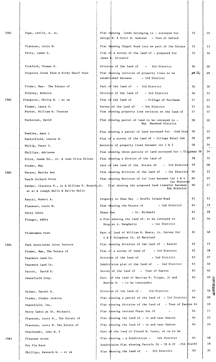
| Pope, Leslie, A. Jr. Plat s :owing lands belonging to - surveyed for 55 05 George W. & Scott W. Andrews - Town of Oxford Plansoen, Louis M. Plat slowing Chapel Road Lots on part of the Estate 55 15 Perry, Lyman S. Plat o a survey of the land of - prepared for 55 46 James . Griswold Pickford, Thomas H. Divisic n of the land of - 2nd District 56 06 Porpoise Creek Farm & Kirby Wharf Farm Plat slowing revision of property lines to be >9 5(e 09 establ shed between - 3rd District Pinder, May- The Estate of Part o: the land of - 3rd District 56 30 Polevoy, Roberta Divisi( n of the land of - 3rd District 56 33 Pierpoint, Philip R. - et ux Plat o: the land of - Village of Fairbank 57 23 Plamer, Laura 0. Survey of the land of - 5th District 57 34 Porter, William W. Trustee Plat slowing property line revision on the land of 57 35 Parkerson, David Plat slowing parcel of land to be conveyed to - 58 10 Bay Hundred District Peebl Am I Plat s owing a parcel of land surveyed for -2nd Dist 58 12 Pastorfield, Louise H. Plat oi a survey of the land of - Village Royal Oak 58 29 Philip, Peter C. Revisit n of property lines between lot 1 & 2 58 34 Phillips, Adrienne Plat s owing three parcels of land surveyed for - Ti ghman 58 34 Price, Jaems Ed., Jr. & Jean Price Wilson Plat s owing a divsion of the land of 58 51 Pinder, May Part o: the land of the Estate of - 3rd District 59 08 Peters, Martha Ann Plat s owing division of the land of - 1st District 60 12 Peach Orchard Point Plat s owing Revision of lot line between lot 3 & 4 60 25 1st Distric t Palmer, Clarence F. , Jr & William F. Howeth,Jr. P at showing the proposed land transfer between 60 27 et al & Joseph Wells & Bellie Wells 5Ch Dlsctlct Pascal, Robert A. Proper y on Shaw Bay - Bruffs Island Road 61 12 Plansoen, Louis M. Plat slowing the Estate of - 2nd District 61 19 Perry Cabin Phase One - St. Michaels 61 28 Pleeger, Addie A Plat showing the land of- to be conveyed to 61 44 Doug as A. Daugherty - 1st District Plimhimmon Farm Part o land of William H. Myers, Jr. Survey for 61 48 C & ' Telephone Co. of Maryland Park Associates Joint Venture Plat s lowing division of the land of - Easton 62 23 Pinder, Mae, The Estate of Plat o a survey of land of - 3rd District 62 38 Peatmore Land Co. Divisi m of the land of - 2nd District 63 07 Peatmore Land Co. Subdiv sion plat of the land of - 2nd District 63 40 Parrot, David S. Survey of the land of - Town of Easton 63 42 Pennsfield Corp. Part >f the land of Barclay H. Trippe, Jr and 63 49 :| -1 Mart la H. - to be conveyedto sj .1 1 Palmer, Daniel H. Divisi >n of the land of - 3rd District 63 50 | Pinder, Gladys Jenkins Plat s lowing a parcel of the land of - 3rd District 64 09 Pennsfield, Inc. Plat slowing division of the land of - Town of Eas on 64 10 Perry Cabin at St. Michaels Plat slowing revised Phase One Of - 64 17 Plansoen, Louis M. , The Estate of Plat s lowing the land of - in and near Easton 64 23 Plansoen, Louis M. The Estate of Plat s lowing the land of - in and near Easton 64 24 Penchenski, John M. P i Part of the land of Elwood W. Cusey, et ux to be Pleasant Acres j Plat s lowing - a Subdivision - 4th District 64 48 I Pot Pie Farm Subdivision Plat showing Parcels 2A - 2B & 2C -5th )ist65 18 Phillips, Kenneth W. - et ux Plat showing the land of - 5th District 65 21 |