 |
||||
|
TALBOT COUNTY CIRCUIT COURT (Plats, Index), 1981-1993 MSA C2400-3 MSA C2400-3, Image No: 36 Enlarge and print image (74K) |
 |
||||
|
TALBOT COUNTY CIRCUIT COURT (Plats, Index), 1981-1993 MSA C2400-3 MSA C2400-3, Image No: 36 Enlarge and print image (74K) |
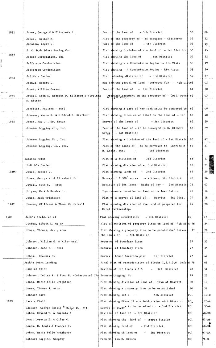
| Jones, George M & Elizabeth J. Part of the land of - 5th District 55 06 Jones, Esther M. Plat of the property of - as occupied - Claiborne 55 52 Johnson, Roger L. Part of the land of - 4th District 55 53 J. C. Dodd Distributing Co. Plat showing division of the land of - 1st District 56 45 Jasper Corporation, The Plat s lowing the land of - ist District 57 32 Jefferson Condominium Plat s lowing - a Condominium Regime - Rio Vista 58 19 Jefferson Condominium Plat s lowing - A Condominium Regime - Rio Vista 58 20 Judith's Garden Plat showing division of - 3rd District 59 37 Joshua, Robert L. Map shewing parcel of land - surveyed for - 4th Di >t61 02 Jones, William Carson Part of the land of - 1st District 61 50 Jewell, Seth S. Rebecca P. Elliason & Virginia Pro posed easement on the property of - (Del. Powe • 62 03 & L ght Co . ) ........ - ,. .. S. Ritter Jeffries, Pauline - etal Plat s lowing a part of New York St. to be conveyed to 62 09 Johnson, Wesua S. & Mildred S. Stafford Plat s lowing lines established on the land of - 1st 62 40 Jones, Ray J , Sr. &etux Survey of the lands of - 5th District 65 29 Johnson Logging co., Inc. Part of the land of - to be conveyed to H. Gilmore 65 29 Gregg - 1st District Johnson Logging Co., Inc. Plat s lowing a division of the land of - 1st Distric : 65 47 Johnson Logging, Co., Inc. Part o: the lands of - to be conveyed to Charles M 67 21 M. Edeis, etal - 1st District m amaica Point Plat oc a division of - 3rd District 68 11 21 Judith's Garden Plat s lowing division of - 3rd District 68 21 ffl 1 Jones, Bessie V. Plat s lowing lands of - 2nd District 69 29 ||| Jones, George M. & Elizabeth J. Survey of 2.000+ acres - Wittman, 5th District 70 34 Jewell, Seth S. - etux Revisi m of lot lines - Right of way - 3rd Distric 71 03 Julyan, Mark & Sandra L. Improv >ments location on land of - Town Oxford 73 14 Jones, Jack Wrightson Plat o: a survey of land of - Neavitt- 2nd Dist. 74 18 Jennes, Millicent & Theo. C. Jeivell Plat Slowing division of the land of prepared for 74 20 Katsi 'artnership. Jack's Field- et al Plat shewing subdivision - 4th District 75 37 Joshua, Robert L. et ux Plat of revision of property lines on land of -4th Di; t 76 34 Jones, Thomas, Jr. , etux Plat sh iwing a property line to be established betweei 77 28 the lan Is of - 5th District Johnson, William G. & Wife- etal Resurve r of boundary lines 77 35 Johnson, Rose E. - etal Resurve r of Boundary lines 77 35 Johns, Chauncy M. Survey c house location plat 1st District 77 42 ack's Point Landing Final P at of resubdivision of Blocks 1,2,4,5,6 Oxfo: d 78 01 Jamaica Point Revison of lot lines 4,& 5 - 3rd District 78 51 Johnson, Dudley R. & Fred H. -CoPartners) T/A Johnson Logging Co. 79 23 Jones, Marie Belle Wrightson Plat sh >wing division of land of - Town of Neavitt 80 19 Jones, Thomas J, etux Plat sh iwing a property line to be established 80 38 Johnson Farm Plat showing lot 1 - 4th District PCI 19-B Jack's Field Plat showing PHase II - a Subdivision -4th District PCI 20-A . . „ nuji.. & ^ r i/ on-1- A- to be added to - 3rd District PCI 30-A Jackson, George Philip " Ralph W. , III Survey of 14.89 Johns, Edward T. & Eugenia A Divisio i of land of - 3rd District PCI 48-BB Jump, Loretta E. & Giles G. Plat showing the land of - Trappe Station PCI 61-BB B Jones, H. Louis & Frances K. Plat showing land of - 2nd District PCI 68-B§ Johns, Marie Belle Wrightson Plat showing th land of - 2nd District PCI 47-AA | Johnson Logging, Company From Wi Ham H. Gibson PCI 76-B |