 |
||||
|
TALBOT COUNTY CIRCUIT COURT (Plats, Index), 1981-1993 MSA C2400-3 MSA C2400-3, Image No: 32 Enlarge and print image (75K) |
 |
||||
|
TALBOT COUNTY CIRCUIT COURT (Plats, Index), 1981-1993 MSA C2400-3 MSA C2400-3, Image No: 32 Enlarge and print image (75K) |
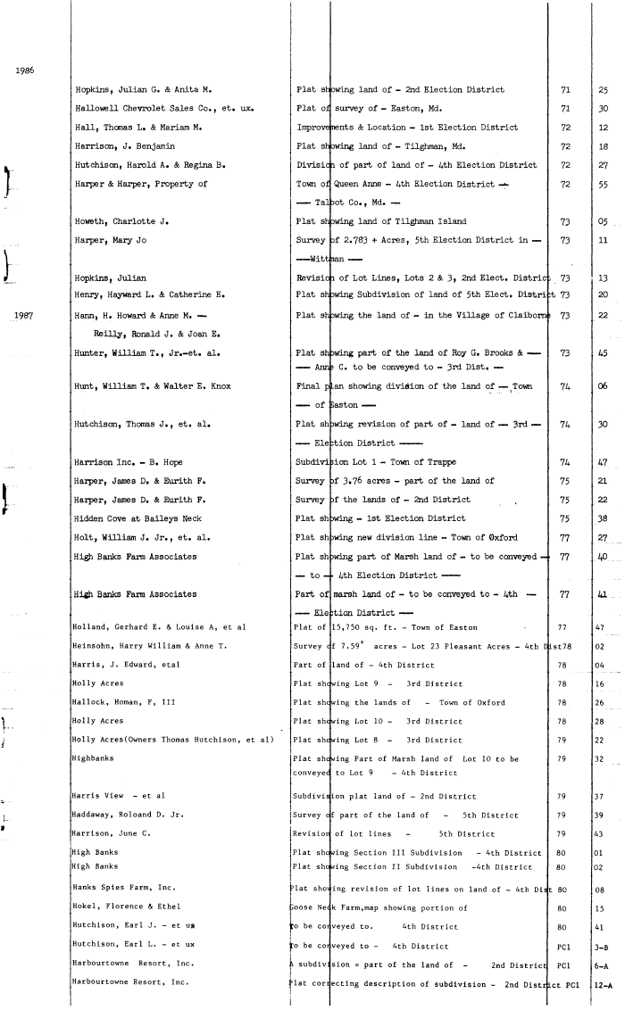
| Hopkins, Julian G. & Anita M. Plat showing land of - 2nd Election District 71 25 Hallowell Chevrolet Sales Co. , et. ux. Plat of survey of - Easton, Md. 71 30 Hall? Thomas L. & Mariam M. Improve nents & Location - 1st Election District 72 12 Harrison, J. Benjamin Plat showing land of - Tilghman, Md. 72 18 Hutchison, Harold A. & Regina B. Divisic i of part of land of - 4th Election District 72 27 Harper & Harper, Property of Town of Queen Anne - 4th Election District -*- 72 55 —— Tal )ot Co. , Md. — Howeth, Charlotte J. Plat showing land of Tilghman Island 73 05 Harper, Mary Jo Survey 3f 2.783 + Acres, 5th Election District in — 73 11 —— Wittnan —— • Hopkins, Julian Revisio i of Lot Lines, Lots 2 & 3» 2nd Elect. Distric , 73 13 Henry, Hayward L. & Catherine E. Plat showing Subdivision of land of 5th Elect. District 73 20 Harm, H. Howard & Anne M. — Plat showing the land of - in the Village of Claiborns 73 22 ReiUy, Ronald J. & Joan E. Hunter, William T., Jr.-et. al. Plat shewing part of the land of Roy G. Brooks & —— 73 45 — — Ann; C. to be conveyed to - 3rd Dist. • — Hunt, William T, & Walter E. Knox Final plan showing division of the land of • — Town 74 06 — — of Caston —— Hutchison, Thomas J. , et. al. Plat sh )wing revision of part of - land of — 3rd — 74 30 —— Ele rtion District ——— Harrison Inc. - B. Hope Subdivi iion Lot 1 - Town of Trappe 74 47 Harper, James D. & Eurith F. Survey >f 3.76 acres - part of the land of 75 21 Harper, James D. & Eurith F. Survey )f the lands of - 2nd District , 75 22 Hidden Cove at Baileys Neck Plat sh >wing - 1st Election District 75 38 Holt, William J. Jr., et. al. Plat sh >wing new division line - Town of Oxford 77 27 High Banks Farm Associates Plat sh >wing part of Marsh land of - to be conveyed — 77 4P — to - • 4th Election District —— High. Banks Farm Associates Part of marsh land of - to be conveyed to - 4th — 77 Al.... —— Ele :tion District —— Holland, Gerhard E. & Louise A, et al Plat of 15,750 sq. ft. - Town of Easton • 77 47 Heinsohn, Harry William & Anne T. Survey cf 7.59+ acres - Lot 23 Pleasant Acres - 4th DLst78 02 Harris, J. Edward, etal Part of land of - 4th District 78 04 Holly Acres Plat shewing Lot 9 - 3rd District 78 16 Hallock, Homan, F, III Plat shewing the lands of - Town of Oxford 78 26 Holly Acres Plat shewing Lot 10 - 3rd District 78 28 Holly Acres(0wners Thomas Hutchison, et al) Plat shewing Lot 8 - 3rd District 79 22 Highbanks Plat shewing Part of Marsh land of Lot 10 to be 79 32 conveyec to Lot 9 - 4th District Harris View - et al Subdivision plat land of - 2nd District 79 37 Haddaway, Roloand D. Jr. Survey cf part of the land of - 5th District 79 39 Harrison, June C. Revisior of lot lines - 5th District 79 43 High Banks Plat showing Section III Subdivision - 4th District 80 01 High Banks Plat showing Section II Subdivision -4th District 80 02 Hanks Spies Farm, Inc. 3lat shoving revision of lot lines on land of - 4th Dist 80 08 Hokel, Florence & Ethel Joose Ne< k Farm, map showing portion of 80 15 Hutchison, Earl J. - et us ;o be coi veyed to. 4th District 80 41 i i Hutchison, Earl L. - et ux To be cot veyed to - 4th District PCI 3-B Harbourtowne Resort, Inc. A subdiv: sion = part of the land of - 2nd District PCI 6-A Harbourtowne Resort, Inc. ;>lat correcting description of subdivision - 2nd District PCI 12-A |