Special Collections
Archives of Maryland
publication of
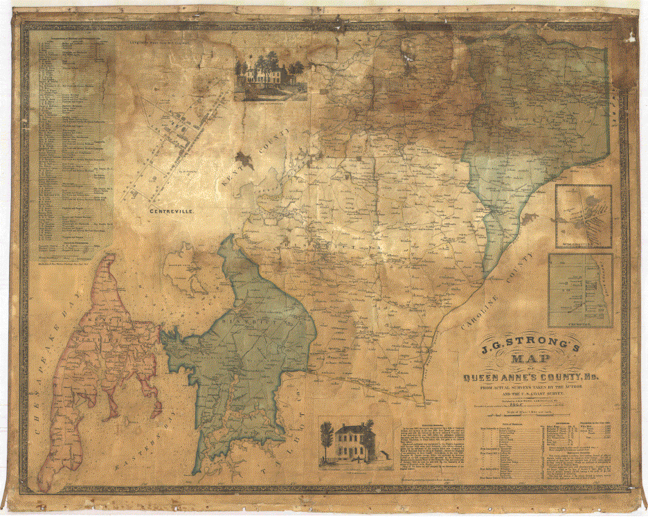
J. G. Strong's Map of Queen Anne's County, 1866
prepared and edited by
Dr. Edward C. Papenfuse,
State Archivist
MSA CD S050000338 available from mdsa.net

| Maryland State Archives
Special Collections Archives of Maryland publication of J. G. Strong's Map of Queen Anne's County, 1866 prepared and edited by Dr. Edward C. Papenfuse, State Archivist MSA CD S050000338 available from mdsa.net |
|
| Collection Number: | MSA SC 5080-1 |
| Collection Name: | Queen Anne's County Historical Society Map Collection |
| Dates: | 1866 |
| Description: | Map, J. G. Strong, Map of Queen Anne's County |
| Medium: | photostats, photographs, 300dpi image files from two different scanners: 02 and 01 (both in Visioneer .exe viewer format of ca. 18 megabytes each) with 01 also in an lzw 300 dpi compressed tif file of ca. 168 megabytes. For faster viewing of a smaller image see 01b (7 megabytes). |
| Restrictions: | use restricted to viewable image files and photographic images; images ©Queen Anne's County Historical Society; fee for commercial, non-educational use |
| Location: | 33/03/04/21 (photographic images); electronic images on Archives of Maryland CD S050000338 |
Notes:
 |
According to Frederic Emory, Queen Anne's County, Maryland (1981 [1886-1887]), p. 532, "The first map of Queen Anne's County in detail was published in 1866 by John G. Strong from surveys made in 1865. An appropriation of $250 by the county in aid of the work was authorized by act of the legislature in 1866." Chapter 143 of the Laws of 1866, passed on January 19, 1866, empowered the "county Commissioners of Queen Anne's County to levy the sum of two hundred and fifty dollars on the taxable property of the County, to pay J. G. Strong for copies of a map of said County which he is about to publish, on the scale of one inch to the mile, and which said copies are intended to be distributed among the Public Schools of the County" (Laws of Maryland, 1866, p. 231). The act permitted the County to reject the maps if there were "not gotten up and published in manner and style as set forth in his, said Strong's programme." The County Commissioners paid the first installment of $125 to Strong by order on James B. Roe, Collector of the District, No. 1, on Tuesday, October 30, 1866. The second and final installment was authorized on Tuesday, April 16, 1867 (Queen Anne's County Board of County Commissioners, (Proceedings), 1861-1869, MSA C 1465-1). For another copy of the Strong map and to view missing data on this map, see the facsimile in MSA SC 1213-481. |
© Copyright Maryland State Archives, Archives of Maryland publication, rev. 4/19/1999.